Passo Garlenda
Passo Garlenda or Passo di Garlenda[2](2021 m) is a mountain pass in the Province of Imperia (Italy). It connects Verdeggia, located in the Argentina Valley, with Monesi di Triora, located in Tanaro Valley.
| Passo Garlenda | |
|---|---|
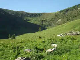 Passo Garlenda from Tanaro valley | |
| Elevation | 2,021 m (6,631 ft)[1] |
| Traversed by | Alta Via dei Monti Liguri |
| Location | Liguria, Italy |
| Range | Ligurian Alps |
| Coordinates | 44°03′03″N 7°44′53″E |
 Passo Garlenda Location of Passo Garlenda | |
Geography
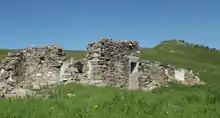
Passo Garlenda is located on the main chain of the Alps between Monte Frontè (2152 m) and Monte Cimonasso [3] (2078 m). Near the pass there are some ruins of old barraks.[2]
Hiking
The pass is accessible by off-road mountain paths coming from the nearby valleys and is crossed by the Alta Via dei Monti Liguri, a long-distance trail from Ventimiglia (province of Imperia) to Bolano (province of La Spezia).[4]
Mountain huts
- Rifugio Sanremo (2,054 m)
References
- Alpi Marittime e Liguri, map 1:50.000 n.8, Istituto Geografico Centrale (Turin)
- Saccarello (Monte) e Monte Frontè anello da Monesi, web page of b.bepun on www.gulliver.it (access: July 29, 2015)
- Also named Monte Simonasso
- IM / 01 - Anello del Saccarello, web page on www.altaviadeimontiliguri.it Archived 2016-03-03 at the Wayback Machine (access: July 29, 2015)
![]() Media related to Passo Garlenda at Wikimedia Commons
Media related to Passo Garlenda at Wikimedia Commons
This article is issued from Wikipedia. The text is licensed under Creative Commons - Attribution - Sharealike. Additional terms may apply for the media files.