Patnitop
{{Infobox settlement
| name =Patnitop
| native_name =
| native_name_lang =
| settlement_type = Hill Station
| image_skyline =Sanasar Lake.jpeg
| image_alt =
| image_caption =Sanasar : A Small Lake in Patnitop
| image_flag =
| flag_alt =
| image_seal =
| seal_alt =
| image_shield =
| shield_alt =
| nickname =
| motto =
| image_map =
| map_alt =
| map_caption =
| pushpin_map = India Jammu and Kashmir#India
| pushpin_label_position =
| pushpin_map_alt =
| pushpin_map_caption = Location in Jammu and Kashmir
| coordinates = 33°5′25″N 75°19′35″E
| coor_pinpoint =
| coordinates_footnotes =
| subdivision_type = Country
|subdivision_name = ![]() India
| subdivision_type1 = [[States of India]
| subdivision_name1 = [[Jammu and Kashmir State
Jammu and Kashmir]]
| subdivision_type2 = District
| subdivision_name2 = Udhampur
| subdivision_type3 =
| subdivision_name3 =
| established_title =
| established_date =
| founder =
| seat_type =
| seat =
| government_footnotes =
| leader_party =
| leader_title =
| leader_name =
| unit_pref = Metric
| area_footnotes =
| area_urban_footnotes =
| area_rural_footnotes =
| area_metro_footnotes =
| area_magnitude =
| area_note =
| area_water_percent =
| area_rank =
| area_blank1_title =
| area_blank2_title =
| area_total_km2 =
| area_land_km2 =
| area_water_km2 =
| area_urban_km2 =
| area_rural_km2 =
| area_metro_km2 =
| area_blank1_km2 =
| area_blank2_km2 =
| area_total_ha =
| area_land_ha =
| area_water_ha =
| area_urban_ha =
| area_rural_ha =
| area_metro_ha =
| area_blank1_ha =
| area_blank2_ha =
| length_km =
| width_km =
| dimensions_footnotes =
| elevation_footnotes =
| elevation_m =2024
| population_footnotes =
| population_total =
| population_as_of =
| population_density_km2 = auto
| population_demonym =
| population_note =
| timezone1 = IST
| utc_offset1 =+5:30
| timezone1_DST =
| utc_offset1_DST =
| postal_code_type =PIN
| postal_code =182142
| area_code_type =
| area_code =
| iso_code =
| website = patnitop
India
| subdivision_type1 = [[States of India]
| subdivision_name1 = [[Jammu and Kashmir State
Jammu and Kashmir]]
| subdivision_type2 = District
| subdivision_name2 = Udhampur
| subdivision_type3 =
| subdivision_name3 =
| established_title =
| established_date =
| founder =
| seat_type =
| seat =
| government_footnotes =
| leader_party =
| leader_title =
| leader_name =
| unit_pref = Metric
| area_footnotes =
| area_urban_footnotes =
| area_rural_footnotes =
| area_metro_footnotes =
| area_magnitude =
| area_note =
| area_water_percent =
| area_rank =
| area_blank1_title =
| area_blank2_title =
| area_total_km2 =
| area_land_km2 =
| area_water_km2 =
| area_urban_km2 =
| area_rural_km2 =
| area_metro_km2 =
| area_blank1_km2 =
| area_blank2_km2 =
| area_total_ha =
| area_land_ha =
| area_water_ha =
| area_urban_ha =
| area_rural_ha =
| area_metro_ha =
| area_blank1_ha =
| area_blank2_ha =
| length_km =
| width_km =
| dimensions_footnotes =
| elevation_footnotes =
| elevation_m =2024
| population_footnotes =
| population_total =
| population_as_of =
| population_density_km2 = auto
| population_demonym =
| population_note =
| timezone1 = IST
| utc_offset1 =+5:30
| timezone1_DST =
| utc_offset1_DST =
| postal_code_type =PIN
| postal_code =182142
| area_code_type =
| area_code =
| iso_code =
| website = patnitop
Dr. Syama Prasad Mookerjee tunnel
Snowfall and avalanche in winter at Patnitop used to obstruct the Jammu-Srinagar National Highway a few times every winter and causes long queues of vehicles, sometimes for days. These problems were mitigated by the opening of the Dr. Syama Prasad Mookerjee Tunnel. At 9.2 km (6 mi), it is India's longest road tunnel. It starts from about 2 km (1 mi) from Chenani town south of Patnitop to Nashri village north of Patnitop, reducing the distance from Jammu to Srinagar by 31 km (19 mi) and bypassing Patnitop.[2]
The Patnitop Ropeway
Skyview Patnitop is India's highest ropeway and the largest Indo-French collaboration in mountain infrastructure development was built in a record time of 2.4 years under the Public-Private Partnership (PPP) model. The ropeway started its commercial operations on July 20 ,2020 . A month after starting its commercial operation, the Skyview Patnitop by Empyrean, an initiative by Empyrean Skyview Projects Private Limited (ESPPL), was awarded the best adventure tourism destination 2019 .It features India's highest ropeway with over 65 meters of ground clearance and the longest span of 849 meters between eight towers . The Ropeway reduces the travel time between sanget & patnitop to 15 minutes from the earlier 1.5 hours .[3]
Gallery
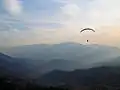 Paragliding at Patnitop
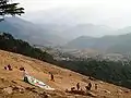 Dawariyai take off area at Patnitop
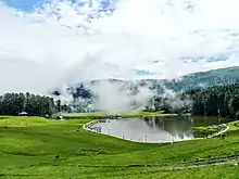 Sanasar Lake
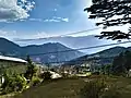 Patnitop Mountains
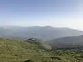
References
- Silas, Sandeep (2005). "17. Patnitop". Discover India by Rail. Sterling Publishers. p. 47. ISBN 81-207-2939-0.
- "Chenani Nashri Tunnel Completes 2 km Excavation". ConstructionWeekOnline.in.
- https://www.theweek.in/wire-updates/business/2019/08/26/nrg19-jk-skyview%20tourism.html
