Patvarc
Patvarc | |
|---|---|
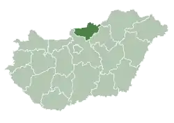
 Patvarc Location of Patvarc | |
| Coordinates: 48.06499°N 19.34880°E | |
| Country | |
| County | Nógrád |
| Government | |
| Area | |
| • Total | 7.84 km2 (3.03 sq mi) |
| Population (2004) | |
| • Total | 670 |
| • Density | 85.45/km2 (221.3/sq mi) |
| Time zone | UTC+1 (CET) |
| • Summer (DST) | UTC+2 (CEST) |
| Postal code | 2668 |
| Area code(s) | 35 |
Patvarc is a village in Nógrád county, Hungary.
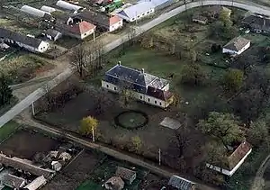
Patvarc from the air
History
At the time of the conquest, the Slavs lived most densely in the Ipoly Valley. The name of the village was given by the Slavs, which suggests that the settlement was known as Patvarc at the time of the conquest. Patvarc is a single-item proper name. The first linguistic memory dates from 1335, where it was read as Potvorch. He's actually the people of a person named Potvor.
Etymology
The name comes from the Slovak/Slavic personal name Potvor (potvora - a monster). Potvorce → Patvarc. See also Potvorice, Potvorov.[1]
External links
- Street map (in Hungarian)
References
- Branislav, Varsik (1994). "Osídlenie Novohradu a Ipeľskej kotliny vo svetle miestnych názvov". Kontinuita medzi veľkomoravskými Slovienmi a stredovekými severouhorskými Slovanmi (Slovákmi) (in Slovak). Veda. p. 115. ISBN 80-224-0175-7.
This article is issued from Wikipedia. The text is licensed under Creative Commons - Attribution - Sharealike. Additional terms may apply for the media files.