Peiros
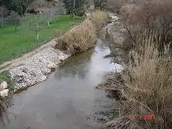
The Peiros (Greek: Πείρος, formerly also Kamenitza and Achelous[1]) is a river in the central and the northwestern parts of Achaea, Greece. It is 42.6 km (26.5 mi) long.[2]
| Peiros | |
|---|---|
 | |
| Native name | Πείρος (Greek) |
| Location | |
| Country | Greece |
| Physical characteristics | |
| Source | |
| • location | Achaea |
| Mouth | |
• location | Gulf of Patras |
• coordinates | 38°9′4″N 21°34′25″E |
| Length | 42.6 km (26.5 mi) |
| Basin size | 578 km2 (223 sq mi) |
| Basin features | |
| Tributaries | |
| • left | Parapeiros, Serdini |
Geography
The Peiros is the second longest river in Achaea, after Selinountas.[2] It rises in the northeastern part of the Erymanthos mountains, near the village Lakkomata. It passes through the municipal units of Farres, Olenia and Dymi. It empties into the Gulf of Patras between the towns Alissos and Kato Achaia. There are several bridges over the Peiros, including the bridges of the Greek National Road 9/E55 (Patras - Pyrgos - Kyparissia) and OSE's Patras–Kyparissia railway line. Two ancient cities were situated near the river: Olenos and Pharae.
Its most important tributaries are the Parapeiros (also known as Tytheus) and the Serdini.
References
-
 Smith, William, ed. (1854). "Achaia". Dictionary of Greek and Roman Geography. 1. London: John Murray. p. 13.
 - Preliminary Flood Risk Assessment Archived 2017-12-09 at the Wayback Machine, Ministry of Environment, Energy and Climate Change, p. 42