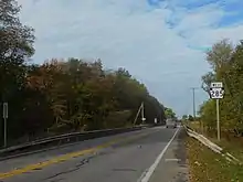
Pennsylvania Route 285
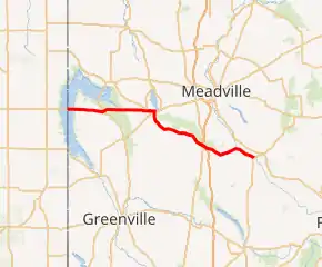
Pennsylvania Route 285 (PA 285) is an 27.1-mile-long (43.6 km), east–west state highway located in Crawford county in Pennsylvania, United States. The western terminus is the Ohio state line on Lake Pymatuning. The eastern terminus is at PA 173 in Cochranton.
| ||||
|---|---|---|---|---|
PA 285 highlighted in red | ||||
| Route information | ||||
| Maintained by PennDOT | ||||
| Length | 27.1 mi[1] (43.6 km) | |||
| Existed | 1936–present | |||
| Tourist routes | Crawford Lakelands Scenic Byway | |||
| Major junctions | ||||
| West end | ||||
| East end | ||||
| Location | ||||
| Counties | Crawford | |||
| Highway system | ||||
| ||||

Route description
PA 285 goes by many names along its route. The names along its route includes Steele's Court, Third Street, Brooks Crossing Road, and Townhouse Court.
The route begins on the Ohio state line over Lake Pymatuning in North Shenango Township, at the terminus of OH 85. The route heads east, going in and out of Pymatuning State Park before short concurrencies with US 6, and US 322/PA 18 in the town of Conneaut Lake. After exiting the town to the south, the route winds southeast to the intersections of US 19 and I-79 in Greenwood Township. The route continues east for several miles before terminating in the town of Cochranton, at an intersection with PA 173.
History
First signed in 1936,[2] the route would be signed in different areas along the route. In the early 1970s, the route was moved from its old alignment from Hartstown Road to Conneaut Lake, where it previously had a concurrency with US 322 into the town. Also in the early 1970s, the route's eastern terminus was moved from US 62 to its current terminus on PA 173.[3][4]
Major intersections
The entire route is in Crawford County.
| Location | mi[1] | km | Destinations | Notes | |
|---|---|---|---|---|---|
| Pymatuning Reservoir | 0.00– 1.34 | 0.00– 2.16 | Continuation into Ohio | ||
| Pymatuning Causeway[5] Pennsylvania–Ohio line | |||||
| Conneaut Lake | 10.7 | 17.2 | Western terminus of US 6 concurrency | ||
| 11.2 | 18.0 | Western terminus of US 322 / PA 18 concurrencies | |||
| 11.2 | 18.0 | Eastern terminus of US 6 / US 322 / PA 18 concurrencies | |||
| Greenwood Township | 19.6 | 31.5 | |||
| 19.8 | 31.9 | Exit 141 (I-79) | |||
| Fairfield Township | 27.1 | 43.6 | Eastern terminus | ||
1.000 mi = 1.609 km; 1.000 km = 0.621 mi
| |||||
See also
 U.S. Roads portal
 Pennsylvania portal
References
- Google (March 17, 2013). "Pennsylvania Route 285" (Map). Google Maps. Google. Retrieved March 17, 2013.
- ftp://ftp.dot.state.pa.us/public/pdf/BPR_PDF_FILES/Maps/Type_10_GHS_Historical_Scans/Crawford_1941_Sheet_2.pdf
- ftp://ftp.dot.state.pa.us/public/pdf/BPR_PDF_FILES/Maps/Type_10_GHS_Historical_Scans/Crawford_1982_Sheet_2.pdf
- ftp://ftp.dot.state.pa.us/public/pdf/BPR_PDF_FILES/Maps/Type_10_GHS_Historical_Scans/Crawford_1982_Sheet_1.pdf
- Pymatuning State Park (PDF) (Map). Cartography by Pennsylvania Department of Conservation and Natural Resources. Pennsylvania Department of Conservation and Natural Resources. 2010-05-18. Retrieved 2013-10-06.
External links
| Wikimedia Commons has media related to Pennsylvania Route 285. |