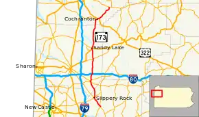
Pennsylvania Route 173
Pennsylvania Route 173 (PA 173) is located in western Pennsylvania, running from PA Route 8 4 miles (6.4 km) south of Slippery Rock in Butler County, to 7.5 miles (12.1 km) north of Cochranton in Crawford County.
| ||||
|---|---|---|---|---|
 | ||||
| Route information | ||||
| Maintained by PennDOT | ||||
| Length | 45.7 mi[1] (73.5 km) | |||
| Major junctions | ||||
| South end | ||||
| North end | ||||
| Location | ||||
| Counties | Butler, Mercer, Crawford | |||
| Highway system | ||||
| ||||
Route description
PA 173 is designated as part of Washington’s Trail between its southern terminus at PA Route 8 and Slippery Rock.[2]
From the village of Stone House at PA Route 8, PA 173 heads north-northeast in Butler County about 4 miles (6.4 km) to the borough of Slippery Rock, home to Slippery Rock University. Near the north end of town, the route intersects with PA 108 at the southern terminus of PA Route 258. Routes 108 and 173 overlap, traveling northeasterly for 0.3 miles (0.48 km), where the concurrency ends and PA 173 turns northward. About 3 miles (4.8 km) later, the route crosses the county line.
After entering Mercer County, PA 173 continues northerly almost 3.5 miles (5.6 km) to the borough of Grove City, the site of Wendall August Forge and Grove City College. The route intersects with PA Route 58, and the two overlap northeastward 0.2 miles (0.32 km). This concurrency ends at the intersection of PA Route 208, where Routes 173 and 208 concurrency northward – for about 0.33 miles (0.53 km), the northbound and southbound lanes run on parallel one-way streets through the downtown area. About 0.4 miles (0.64 km) later, the concurrency ends, PA 173 continues north, and leaves the borough. The route interchanges with I-80 about 2.5 miles (4.0 km) later, and then intersects with PA Route 965 about 6 miles (9.7 km) after that at the village of Perrine’s Corners.
PA 173 enters the borough of Sandy Lake 4 miles (6.4 km) later, where it forms a brief concurrency with US 62; the concurrency ends at the eastern terminus of PA Route 358. PA 173 leaves the borough, and just over 4 miles (6.4 km) later, intersects with Georgetown Rd., which is the former alignment of PA Route 285 in the borough of New Lebanon. The route passes through the village of Milledgeville 4 miles (6.4 km) north, and then crosses the county line just over 1 mile (2 km) after that.
A little more than 2 miles (3.2 km) after entering Crawford County, PA 173 turns northeasterly as it intersects with the eastern terminus of PA Route 285, and then enters the borough of Cochranton shortly thereafter. In Cochranton, the route intersects with the former alignment of US 322, and then 0.6 miles (0.97 km) later, after leaving the borough, it intersects with the current alignment of US 322. Not quite 2 miles (3.2 km) later, the route passes through the village of Kasters Corners, and then runs another 5 miles (8.0 km) before its northern terminus at PA Route 27.
History
In 1926, the segment from Stone House to Slippery Rock was designated as PA 8. In 1941, the entire alignment was designated as PA 78 before receiving the current number in 1961.[2]
Major intersections
| County | Location | mi[1] | km | Destinations | Notes |
|---|---|---|---|---|---|
| Butler | Brady Township | 0.0 | 0.0 | Southern terminus | |
| Slippery Rock | 4.6 | 7.4 | Southern terminus of PA 108 concurrency; southern terminus of PA 258 | ||
| 4.9 | 7.9 | Northern terminus of PA 108 concurrency | |||
| Mercer | Grove City | 11.5 | 18.5 | Southern terminus of PA 58 concurrency | |
| 11.7 | 18.8 | Northern terminus of PA 58 concurrency; southern terminus of PA 208 concurrency | |||
| 12.5 | 20.1 | Northern terminus of PA 208 concurrency | |||
| Wolf Creek Township | 15.1 | 24.3 | Exit 24 (I-80) | ||
| Worth Township | 21.2 | 34.1 | |||
| Sandy Lake | 25.4 | 40.9 | Southern terminus of US 62 concurrency | ||
| 25.6 | 41.2 | Northern terminus of US 62 concurrency; eastern terminus of PA 358 | |||
| Crawford | Fairfield Township | 37.5 | 60.4 | Eastern terminus of PA 285 | |
| Wayne Township | 38.7 | 62.3 | |||
| Randolph Township | 45.7 | 73.5 | Northern terminus | ||
1.000 mi = 1.609 km; 1.000 km = 0.621 mi
| |||||
See also
 U.S. Roads portal
 Pennsylvania portal
References
- Google (June 14, 2013). "Pennsylvania Route 173" (Map). Google Maps. Google. Retrieved June 14, 2013.
- Pennsylvania Highways - Pennsylvania Route 173
