Pennsylvania Route 310
Pennsylvania Route 310 (PA 310) is a 12.6-mile-long (20.3 km) state highway located in Jefferson County, Pennsylvania. The southern terminus is at US 119 in Punxsutawney. The northern terminus is at US 322 in Reynoldsville.
| ||||
|---|---|---|---|---|
 | ||||
| Route information | ||||
| Maintained by PennDOT | ||||
| Length | 12.552 mi[1] (20.200 km) | |||
| Major junctions | ||||
| South end | ||||
| North end | ||||
| Location | ||||
| Counties | Jefferson | |||
| Highway system | ||||
| ||||

Route description
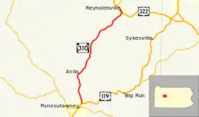
PA 310 begins at an intersection with US 119 in the borough of Punxsutawney, heading north on two-lane undivided Elk Run Avenue. The road runs through commercial areas before crossing a Buffalo and Pittsburgh Railroad line and passing homes. The route crosses into Young Township and becomes Harmony Road, heading into more wooded areas with a few residences as it comes to the community of Harmony. At this point, PA 310 winds north thorough more woodland with some fields and homes, passing through Crawfordtown. The road enters McCalmont Township and becomes Main Street, turning northeast and running through the residential community of Anita. From this point, the route heads north again through more forests before coming into areas of agriculture with some homes and passing through Panic. PA 310 heads northeast into Winslow Township and runs through farmland and woodland with occasional residences as an unnamed road. The route continues northeast through more rural areas before heading into the borough of Reynoldsville and becoming Bradford Street, passing homes. PA 310 turns northwest onto Jackson Street and continues through more residential areas. The route turns northeast onto South 5th Street and heads into business areas, ending at US 322.[2][3]
Major intersections
The entire route is in Jefferson County.
| Location | mi[1] | km | Destinations | Notes | |
|---|---|---|---|---|---|
| Punxsutawney | 0.000 | 0.000 | Southern terminus | ||
| Reynoldsville | 12.552 | 20.200 | Northern terminus | ||
| 1.000 mi = 1.609 km; 1.000 km = 0.621 mi | |||||
See also
 U.S. Roads portal
 Pennsylvania portal
References
- "Pennsylvania state roads". Pennsylvania Spatial Data Access. Pennsylvania Department of Transportation. 2013. Retrieved March 14, 2013.
- Google (June 2, 2011). "overview of Pennsylvania Route 310" (Map). Google Maps. Google. Retrieved June 2, 2011.
- Jefferson County, Pennsylvania Highway Map (PDF) (Map). PennDOT. 2011. Archived from the original (PDF) on August 10, 2011. Retrieved June 2, 2011.