Pennsylvania Route 867
Pennsylvania Route 867 (PA 867) is a 12-mile-long (19 km) state highway located in Bedford and Blair counties in Pennsylvania. The southern terminus is at PA 869 in South Woodbury Township. The northern terminus is at PA 36/PA 164 outside of Roaring Spring.
| ||||
|---|---|---|---|---|
| ||||
| Route information | ||||
| Maintained by PennDOT, Taylor Township, Borough of Roaring Spring | ||||
| Length | 12.211 mi[1][2][3] (19.652 km) | |||
| Existed | 1928–present | |||
| Major junctions | ||||
| South end | ||||
| North end | ||||
| Location | ||||
| Counties | Bedford, Blair | |||
| Highway system | ||||
| ||||

Route description
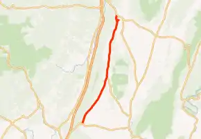
PA 867 begins at an intersection with PA 869 in the community of Brumbaugh in South Woodbury Township, Bedford County, heading northeast on two-lane undivided Lafayette Road. The road heads between forested Dunning Mountain to the west and farms to the east. The route passes through more agricultural areas in a valley with occasional homes, passing through Lafayetteville before crossing into Bloomfield Township. In this area, PA 867 runs through more rural surroundings, coming to an intersection with the northern terminus of PA 868. Past this intersection, the road continues north through more farmland with some woods and residences, heading through Bakers Summit.[4][5]

PA 867 enters Taylor Township in Blair County and runs north-northeast through agricultural areas with woods and homes, becoming Bloomfield Road. Though the road was maintained by the Pennsylvania Department of Transportation (PennDOT) in Bedford County, maintenance on PA 867 in Taylor Township and Roaring Spring is performed by the respective municipality in Blair County.[1][2][3] The road continues through rural areas before heading into the borough of Roaring Spring and becoming Bloomfield Street, heading north past homes. The route turns north onto Main Street and crosses the Hollidaysburg and Roaring Spring Railroad, heading into residential and commercial areas. At the intersection with Spang Street, PA 867 becomes a one-way pair with the southbound direction continuing along one-way Main Street and the northbound direction heading northeast on two-way Spang Street before heading northwest on one-way East Main Street. The two directions of the route merge back together and continue north on Main Street between industrial areas to the west and homes to the east. PA 864 crosses back into Taylor Township and heads through wooded areas, ending at an intersection with PA 36/PA 164.[4][6]
Major intersections
| County | Location | mi[1][2][3] | km | Destinations | Notes |
|---|---|---|---|---|---|
| Bedford | South Woodbury Township | 0.000 | 0.000 | Southern terminus | |
| Bloomfield Township | 5.555 | 8.940 | Northern terminus of PA 868 | ||
| Blair | Taylor Township | 12.211 | 19.652 | Northern terminus | |
| 1.000 mi = 1.609 km; 1.000 km = 0.621 mi | |||||
PA 867 Truck
| |
|---|---|
| Location | Blair County |
Pennsylvania Route 867 Truck is a truck route of PA 867 following Interstate 99, PA 869, and PA 36/164 until the road ends and begins at PA 867. It bypasses a weight-restricted bridge over a tributary of Halter Creek on which trucks on which trucks and combination loads over 36 tons are prohibited. It was signed in 2013.[7]
See also
 U.S. Roads portal
 Pennsylvania portal
References
- Bureau of Maintenance and Operations (January 2019). Roadway Management System Straight Line Diagrams (Report) (2019 ed.). Pennsylvania Department of Transportation. Retrieved March 8, 2019.
- Bedford County (PDF)
- Blair County (PDF)
- Taylor Second Class Township Map, Blair County (PDF) (Map). PennDOT. December 21, 2016. Retrieved March 8, 2019.
- Roaring Spring Borough, Cambria County (PDF) (Map). PennDOT. June 22, 2006. Retrieved March 8, 2019.
- Google (June 29, 2011). "overview of Pennsylvania Route 867" (Map). Google Maps. Google. Retrieved June 29, 2011.
- Bedford County, Pennsylvania Highway Map (PDF) (Map). PennDOT. 2018. Retrieved March 8, 2019.
- Blair County, Pennsylvania Highway Map (PDF) (Map). PennDOT. 2018. Retrieved March 8, 2019.
- "Risk-Based Bridge Postings - State and Local Bridges" (PDF). Pennsylvania Department of Transportation. October 8, 2013. Retrieved May 19, 2016.
External links
| Wikimedia Commons has media related to Pennsylvania Route 867. |