Pennsylvania Route 868
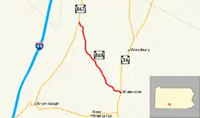
Pennsylvania Route 868 (PA 868) is a 5.23-mile-long (8.42 km) state highway located in Bedford county in Pennsylvania. The southern terminus is at PA 36 in South Woodbury Township. The northern terminus is at PA 867 in Bloomfield Township.
| ||||
|---|---|---|---|---|
 | ||||
| Route information | ||||
| Maintained by PennDOT | ||||
| Length | 5.23 mi[1] (8.42 km) | |||
| Existed | 1928–present | |||
| Major junctions | ||||
| South end | ||||
| North end | ||||
| Location | ||||
| Counties | Bedford | |||
| Highway system | ||||
| ||||

Route description
PA 868 begins at an intersection with PA 36 in the community of Waterside in South Woodbury Township, heading northwest on two-lane undivided Potter Creek Road. The road heads through an agricultural valley with some woods and residences, passing through a corner of Woodbury Township before entering Bloomfield Township. The route passes through the community of Maria prior to continuing through more forested areas with some farm fields and homes. PA 868 curves to the north through open farmland and comes to its northern terminus at PA 867.[2][3]
Major intersections
The entire route is in Bedford County.
| Location | mi[1] | km | Destinations | Notes | |
|---|---|---|---|---|---|
| South Woodbury Township | 0.00 | 0.00 | Southern terminus | ||
| Bloomfield Township | 5.23 | 8.42 | Northern terminus | ||
| 1.000 mi = 1.609 km; 1.000 km = 0.621 mi | |||||
See also
 U.S. Roads portal
 Pennsylvania portal
References
- "Pennsylvania state roads". Pennsylvania Spatial Data Access. Pennsylvania Department of Transportation. 2012. Retrieved December 24, 2012.
- Google (May 20, 2011). "overview of Pennsylvania Route 868" (Map). Google Maps. Google. Retrieved May 20, 2011.
- Bedford County, Pennsylvania Highway Map (PDF) (Map). PennDOT. 2011. Retrieved May 20, 2011.