Pennsylvania Route 978
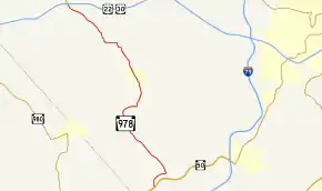
Pennsylvania Route 978 (PA 978) is a 9.7-mile-long (15.6 km) north–south state highway located in western Allegheny County, Pennsylvania. The southern terminus of the route is at PA 50 in the vicinity of the Cecil area (of Washington County, although the road remains in Allegheny County) and of the Gladden area. The highway heads slightly to the northwest, and reaches the northern terminus at the interchange with U.S. Route 22 (US 22) and US 30 in the Imperial-Enlow area.
| ||||
|---|---|---|---|---|
 | ||||
| Route information | ||||
| Maintained by PennDOT | ||||
| Length | 9.700 mi[1] (15.611 km) | |||
| Existed | 1928–present | |||
| Major junctions | ||||
| South end | ||||
| North end | ||||
| Location | ||||
| Counties | Allegheny | |||
| Highway system | ||||
| ||||

Route description
PA 978 begins at a signalized intersection with PA 50. It heads north and crosses a railroad at an at-grade crossing. Shortly after this, PA 978 curves northeast paralleling the railroad and Millers Run. The road then turns north after intersecting Millers Run Road.
When meeting Robinson Run Road, the road turns due east, and then turns west at its intersection with Battle Ridge Road, the south end of the concurrency with the Orange Belt. It later reaches the borough of Oakdale, where there is an intersection with Noblestown Road. At a fork with McKee Road north of Oakdale, PA 978 keeps left, while the Orange Belt keeps right toward the Pittsburgh Technical College. The road later turns west at Oakdale Road and turns north after intersecting North Branch Road. The route's western terminus occurs at an interchange with US 22/US 30 in the Imperial-Enlow area.
History
Old PA 978 was a road located in Imperial-Enlow. It existed for roughly 40 years and later was not renamed. It was commissioned in the 1930s and decommissioned in the mid 1970s. The growth of Pittsburgh International Airport partly led to PA 978 being realigned, and the old road later being closed to traffic, especially after the construction of the Midfield Temrinal in the 1990s. Enlow Road, now an Allegheny County maintained road, was one of the local roads that once carried PA 978. It also was one of the many roads that have disappeared with the expansion of the Pittsburgh International Airport. In Enlow, there is still is a few signs that keep the 978 designation alive. Old PA 978 begins at the Steubenville Pike south of the Robinson Town Centre just outside Imperial, and soon passes over the Montour Trail and merge with Cliff Mine Road. The road passes through several neighborhoods before encountering a fork, where the road keeps left. After passing by more neighborhoods for around three miles, the road travels by Interstate 376, which is on the right. The road ends at US 30.
Major intersections
The entire route is in Allegheny County.
| Location | mi[2] | km | Destinations | Notes | |
|---|---|---|---|---|---|
| South Fayette Township | 0.00 | 0.00 | Southern terminus | ||
| 0.83 | 1.34 | Millers Run Road – Sygan | |||
| 4.38 | 7.05 | South end of concurrency with Orange Belt | |||
| Oakdale | 5.35 | 8.61 | Noblestown Road – Pittsburgh Botanic Garden | ||
| North Fayette Township | 6.27 | 10.09 | North end of concurrency with Orange Belt | ||
| 7.49 | 12.05 | North Branch Road – McDonald | |||
| 9.70 | 15.61 | Interchange; northern terminus | |||
| 1.000 mi = 1.609 km; 1.000 km = 0.621 mi | |||||
See also
 U.S. Roads portal
 Pennsylvania portal
References
- "Pennsylvania state roads". Pennsylvania Spatial Data Access. Pennsylvania Department of Transportation. 2012. Retrieved December 25, 2012.
- "PennDOT VideoLog - Allegheny County - Route 0978". Pennsylvania Department of Transportation. August 6, 2010. Retrieved December 29, 2012.
External links
- Allegheny County, Pennsylvania General Highway Map (PDF) (Map). PennDOT. 2012. Archived from the original (PDF) on 2011-07-20.
- Pennsylvania Highways - Pennsylvania Route 978
- Former Alignments of PA 978; Allegheny County
