Pennypack Trail
The Pennypack Trail is a rail trail located in eastern Montgomery County, Pennsylvania in the United States. The trail runs 5.4 miles (8.7 km) from Rockledge north to Byberry Road near Bryn Athyn along the former alignment of SEPTA's Fox Chase-Newtown Line. The trail is maintained by the Montgomery County Division of Parks, Trails, & Historic Sites.
| Pennypack Trail | |
|---|---|
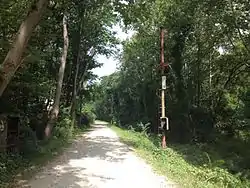 Pennypack Trail north of Lorimer Park, with a former railroad signal pole visible | |
| Length | 5.4 mi (8.7 km) |
| Trailheads | Rockledge, Pennsylvania 40°05′05″N 75°05′01″W Byberry Road 40°09′26″N 75°04′22″W |
| Use | Multi-use, non-motorized |
| Hiking details | |
| Season | Year-round, no winter maintenance |
| Surface | Crushed stone |
Route
The Pennypack Trail begins in the borough of Rockledge near Rockledge Borough Park at the intersection of Robbins and Rockledge avenues. After beginning, the trail passes over Shady Lane before heading over a stream valley on a 165-foot (50 m) long, 35-foot (11 m) high bridge. From here, the Pennypack Trail continues north into Abington Township and forms the western border of Lorimer Park, which has a trail network along with parking, picnic areas, restrooms, and water fountains. Here, the trail crosses Moredon Road and begins to run parallel to Pennypack Creek on the west bank. Past here, the trail heads north and crosses the creek before passing under Pennsylvania Route 232 (Huntingdon Pike). The trail enters Lower Moreland Township and heads across the Pennypack Creek again before coming to a grade crossing with SEPTA's West Trenton Line. The trail heads across the Bethayres Swamp before it reaches Pennsylvania Route 63 (Welsh Road). The trail crosses Terwood Road before it heads across the Pennypack Creek on a 165-foot (50 m) long bridge and then enters Bryn Athyn. The Pennypack Trail crosses Fetters Mill Road near the Bryn Athyn station, which serves as a post office. The trail heads north through the Pennypack Ecological Restoration Trust. Near Creek Road, the trail passes the site of a train wreck in 1921 where two trains collided head-on. The trail currently terminates at Byberry Road, with an extension planned north to County Line Road at the Bucks County border.[1][2]
History

What is now the Pennypack Trail was originally part of the Philadelphia, Newtown and New York Railroad, a railroad line that ran from Philadelphia north to Newtown. The line was part of the Reading Railroad system and was electrified between Center City Philadelphia and Fox Chase, with service between Fox Chase and Newtown powered by diesel trains. Passengers traveling from north of Fox Chase had to transfer from diesel to electric trans in Fox Chase, and vice versa. In 1976, the Reading Railroad became a part of Conrail. SEPTA acquired operation of the line in 1981, which became its Fox Chase-Newtown Line. In January 1983, SEPTA suspended service between Fox Chase and Newtown because of low ridership, a labor dispute, and failing diesel equipment on this section of line, which lacked electrification. For several years, the tracks sat dormant, became overgrown with trees, and saw several bridges collapse. In 2009, Montgomery County turned a section of this former railroad line along the western edge of Lorimer Park into the Pennypack Trail. As part of constructing the trail, Montgomery County leased the right-of-way from SEPTA for $1 and the rails were removed and sold. SEPTA continues to own the right-of-way so passenger rail service could be restored in the future, though there are no plans to do so.[3][4][5] The Pennypack Trail was extended north from Welsh Road to Byberry Road on September 18, 2015.[6]
References
- "Pennypack Trail". Montgomery County, Pennsylvania. Retrieved September 21, 2016.
- Pennypack Trail (Map). Montgomery County Division of Parks, Trails, & Historic Sites. Retrieved September 21, 2016.
- Nussbaum, Paul (October 9, 2009). "A Bucks-Montco debate Newtown Station: Reopen it or not?". The Philadelphia Inquirer. Retrieved August 8, 2011.
- Nussbaum, Paul (March 23, 2014). "Montco plans to convert more of rail line for recreation". The Philadelphia Inquirer. Retrieved April 21, 2014.
- Staff (June 6, 2014). "Montgomery County Commissioners break ground on Pennypack Trail extension". The Times Herald. Norristown, PA. Retrieved September 21, 2016.
- Sokil, Dan (September 18, 2015). "Montgomery County commissioners cut ribbon for Trail extension". The Reporter. Lansdale, PA. Retrieved September 21, 2016.
External links
 Media related to Pennypack Trail at Wikimedia Commons
| ||