Pers, Cantal
Pers is a former commune in the Cantal department in south-central France. On 1 January 2016, it was merged into the new commune Le Rouget-Pers.[2]
Pers | |
|---|---|
Part of Le Rouget-Pers | |
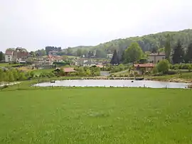 A general view of Pers | |
 Coat of arms | |
Location of Pers 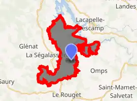
| |
 Pers  Pers | |
| Coordinates: 44°53′17″N 2°14′22″E | |
| Country | France |
| Region | Auvergne-Rhône-Alpes |
| Department | Cantal |
| Arrondissement | Aurillac |
| Canton | Saint-Mamet-la-Salvetat |
| Commune | Le Rouget-Pers |
| Area 1 | 16.05 km2 (6.20 sq mi) |
| Population (2017)[1] | 277 |
| • Density | 17/km2 (45/sq mi) |
| Time zone | UTC+01:00 (CET) |
| • Summer (DST) | UTC+02:00 (CEST) |
| Postal code | 15290 |
| Elevation | 516–657 m (1,693–2,156 ft) (avg. 570 m or 1,870 ft) |
| 1 French Land Register data, which excludes lakes, ponds, glaciers > 1 km2 (0.386 sq mi or 247 acres) and river estuaries. | |
It is on the edge of the Chataignerie and near the Segala. It is also adjacent to the lake of St Etienne Cantales, a large body of water formed by the damming of the Cere river for hydro electric purposes.
The village also has a very good go-cart track, and regularly hosts championship races.
As well as the church and the town hall, there are two bars, and a camping site. Gites may also be rented from the farm. There are no shops.
Population
| Year | Pop. | ±% |
|---|---|---|
| 1962 | 293 | — |
| 1968 | 327 | +11.6% |
| 1975 | 266 | −18.7% |
| 1982 | 244 | −8.3% |
| 1990 | 209 | −14.3% |
| 1999 | 234 | +12.0% |
| 2008 | 297 | +26.9% |
See also
References
- Téléchargement du fichier d'ensemble des populations légales en 2017, INSEE
- Arrêté préfectoral 4 December 2015 (in French)
| Wikimedia Commons has media related to Pers (Cantal). |
| Authority control |
|---|
This article is issued from Wikipedia. The text is licensed under Creative Commons - Attribution - Sharealike. Additional terms may apply for the media files.