Arrondissement of Aurillac
The arrondissement of Aurillac is an arrondissement of France in the Cantal department in the Auvergne-Rhône-Alpes region. It has 93 communes.[1] Its population is 82,391 (2016), and its area is 1,936.9 km2 (747.8 sq mi).[2]
Aurillac | |
|---|---|
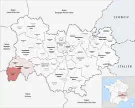 Location within the region Auvergne-Rhône-Alpes | |
| Country | France |
| Region | Auvergne-Rhône-Alpes |
| Department | Cantal |
| No. of communes | 93 |
| Prefecture | Aurillac |
| Area | |
| • Total | 1,936.9 km2 (747.8 sq mi) |
| Population (2016) | |
| • Total | 82,391 |
| • Density | 43/km2 (110/sq mi) |
| INSEE code | 151 |
Composition
The communes of the arrondissement of Aurillac, and their INSEE codes, are:[1]
- Arnac (15011)
- Arpajon-sur-Cère (15012)
- Aurillac (15014)
- Ayrens (15016)
- Badailhac (15017)
- Besse (15269)
- Boisset (15021)
- Carlat (15028)
- Cassaniouze (15029)
- Cayrols (15030)
- Crandelles (15056)
- Cros-de-Montvert (15057)
- Cros-de-Ronesque (15058)
- Freix-Anglards (15072)
- Giou-de-Mamou (15074)
- Girgols (15075)
- Glénat (15076)
- Jou-sous-Monjou (15081)
- Junhac (15082)
- Jussac (15083)
- Labesserette (15084)
- Labrousse (15085)
- Lacapelle-Viescamp (15088)
- Lacapelle-del-Fraisse (15087)
- Ladinhac (15089)
- Lafeuillade-en-Vézie (15090)
- Lapeyrugue (15093)
- Laroquebrou (15094)
- Laroquevieille (15095)
- Lascelle (15096)
- Leucamp (15103)
- Leynhac (15104)
- Mandailles-Saint-Julien (15113)
- Marcolès (15117)
- Marmanhac (15118)
- Maurs (15122)
- Montmurat (15133)
- Montsalvy (15134)
- Montvert (15135)
- Naucelles (15140)
- Nieudan (15143)
- Omps (15144)
- Pailherols (15146)
- Parlan (15147)
- Polminhac (15154)
- Prunet (15156)
- Puycapel (15027)
- Quézac (15157)
- Raulhac (15159)
- Reilhac (15160)
- Roannes-Saint-Mary (15163)
- Rouffiac (15165)
- Le Rouget-Pers (15268)
- Roumégoux (15166)
- Rouziers (15167)
- Saint-Antoine (15172)
- Saint-Cernin (15175)
- Saint-Cirgues-de-Jordanne (15178)
- Saint-Cirgues-de-Malbert (15179)
- Saint-Clément (15180)
- Saint-Constant-Fournoulès (15181)
- Saint-Étienne-Cantalès (15182)
- Saint-Étienne-de-Carlat (15183)
- Saint-Étienne-de-Maurs (15184)
- Saint-Gérons (15189)
- Saint-Illide (15191)
- Saint-Jacques-des-Blats (15192)
- Saint-Julien-de-Toursac (15194)
- Saint-Mamet-la-Salvetat (15196)
- Saint-Paul-des-Landes (15204)
- Saint-Santin-Cantalès (15211)
- Saint-Santin-de-Maurs (15212)
- Saint-Saury (15214)
- Saint-Simon (15215)
- Saint-Victor (15217)
- Sansac-Veinazès (15222)
- Sansac-de-Marmiesse (15221)
- La Ségalassière (15224)
- Sénezergues (15226)
- Siran (15228)
- Teissières-de-Cornet (15233)
- Teissières-lès-Bouliès (15234)
- Thiézac (15236)
- Tournemire (15238)
- Le Trioulou (15242)
- Velzic (15252)
- Vézac (15255)
- Vezels-Roussy (15257)
- Vic-sur-Cère (15258)
- Vieillevie (15260)
- Vitrac (15264)
- Yolet (15266)
- Ytrac (15267)
History
The arrondissement of Aurillac was created in 1800.[3]
As a result of the reorganisation of the cantons of France which came into effect in 2015, the borders of the cantons are no longer related to the borders of the arrondissements. The cantons of the arrondissement of Aurillac were, as of January 2015:[4]
- Arpajon-sur-Cère
- Aurillac-1
- Aurillac-2
- Aurillac-3
- Aurillac-4
- Jussac
- Laroquebrou
- Maurs
- Montsalvy
- Saint-Cernin
- Saint-Mamet-la-Salvetat
- Vic-sur-Cère
References
- "Arrondissement d'Aurillac (151)". INSEE. Retrieved 2019-09-27.
- "Comparateur de territoire, géographie au 01/01/2019". INSEE. Retrieved 2019-09-27.
- Historique du Cantal
- "Populations légales 2012" (PDF). INSEE. December 2014. Retrieved 2019-10-08.
This article is issued from Wikipedia. The text is licensed under Creative Commons - Attribution - Sharealike. Additional terms may apply for the media files.