Phalut
Phalut or Falut (3600 m) is the second highest peak of West Bengal, India. Part of the Singalila Ridge in the Himalayas, it is located at the border of the Indian states of West Bengal and Sikkim and of Nepal. It is located inside the Singalila National Park. A small bunkhouse is near the top of the peak and is administered by the Indian army. Singalila Pass is 17 km away from Phalut.
Phalut | |
|---|---|
Village | |
 Phalut Location in West Bengal, India  Phalut Phalut (India) | |
| Coordinates: 27°10′16″N 88°01′12″E | |
| Country | |
| State | West Bengal |
| District | Darjeeling |
| Population (2011) | |
| • Total | 1,633 |
| Languages | |
| • Official | Nepali, English |
| Time zone | UTC+5:30 (IST) |
| Vehicle registration | WB |
| Website | www |
The indigenous tribes surrounding the mountain peak are known as Falutians by outsiders. Falutians have a 300-year history of worshipping the mountain peak, and believe that Phalut is an omniscient god. They refer to the mountain peak as "Omna Re Ay".
| Places and tea estates in the north-western portion of Darjeeling Sadar subdivision (including Darjeeling Pulbazar CD block) in Darjeeling district CT: census town, R: rural/ urban centre, N: neighbourhood, H: hill centre, NP: national park/ wildlife sanctuary, TE: tea estate, TA: tourist attraction Abbreviations used in names – TG for Tea Garden (town/village), TE for Tea Estate Owing to space constraints in the small map, the actual locations in a larger map may vary slightly |
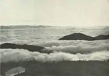
Cloud effect from Phalut, c. 1905

A view of the Himalayan peaks of (from the left) Mt.Lhotse, Mt.Everest, Mt.Makalu and Mt.Chomolonzo from Phalut in West Bengal, India.
This article is issued from Wikipedia. The text is licensed under Creative Commons - Attribution - Sharealike. Additional terms may apply for the media files.