Philmont, New York
Philmont is a village in Columbia County, New York, United States. The population was 1,379 at the 2010 census.[3] The village is located in the northeast part of the town of Claverack on New York State Route 217.
Philmont, New York | |
|---|---|
Village | |
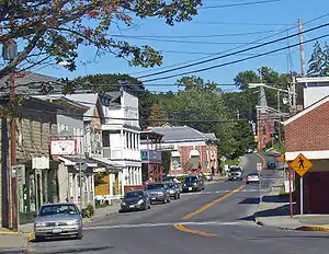 Downtown Philmont, looking east along NY 217 | |
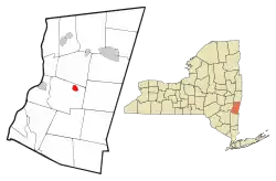 Location of Philmont, New York | |
.svg.png.webp) Location of New York in the United States | |
| Coordinates: 42°14′56″N 73°38′56″W | |
| Country | United States |
| State | New York |
| County | Columbia |
| Founded | 1892 |
| Government | |
| • Mayor | Clarence Speed |
| Area | |
| • Total | 1.23 sq mi (3.18 km2) |
| • Land | 1.19 sq mi (3.08 km2) |
| • Water | 0.04 sq mi (0.10 km2) |
| Elevation | 500 ft (200 m) |
| Highest elevation (Unnamed hill in SE quadrant of village) | 690 ft (210 m) |
| Lowest elevation (Agawamuck Creek on W boundary) | 280 ft (90 m) |
| Population (2010) | |
| • Total | 1,379 |
| • Estimate (2019)[2] | 1,258 |
| • Density | 1,059.81/sq mi (409.06/km2) |
| Time zone | UTC-5 (Eastern (EST)) |
| • Summer (DST) | UTC-4 (EDT) |
| ZIP Code | 12565 |
| Area code(s) | 518 |
| FIPS code | 36-57639 |
| GNIS feature ID | 0960311 |
| Website | www |
History
The community was once known as "Factory Hill" due to the number of wool factories. The village was incorporated in 1891. It derives its name from George P. Philip, who built a 36-acre (15 ha) reservoir to provide water for his mill. This in turn led to construction of a 56-acre (23 ha) reservoir up the "mountain" in the Taconic Mountains to guarantee water to the mills, thus creating the factory hill.[4]
Past residents of note
- Oliver North, United States Marine Corps officer and Fox News contributor
- Claude Rossman, Major League Baseball player from 1904-1909
- Barbara Lehman, author illustrator of children's books of universal appeal
- Bradford Race, Chief of Staff to Governor George Pataki 1995-2002
Geography
Philmont is located at 42°14′55″N 73°38′51″W (42.248620, -73.647602).[5]
According to the United States Census Bureau, the village has a total area of 1.23 square miles (3.18 km2), of which 1.19 square miles (3.08 km2) is land and 0.04 square miles (0.10 km2), or 3.16%, is water.[3]
The village is along Agawamuck Creek, which drops over its High Falls near the center of the village. The creek is a tributary of Claverack Creek, which flows about 7.5 miles (12.1 km) to the Hudson River.
Demographics
| Historical population | |||
|---|---|---|---|
| Census | Pop. | %± | |
| 1880 | 1,343 | — | |
| 1890 | 1,818 | 35.4% | |
| 1900 | 1,964 | 8.0% | |
| 1910 | 1,813 | −7.7% | |
| 1920 | 1,919 | 5.8% | |
| 1930 | 1,868 | −2.7% | |
| 1940 | 1,679 | −10.1% | |
| 1950 | 1,792 | 6.7% | |
| 1960 | 1,750 | −2.3% | |
| 1970 | 1,674 | −4.3% | |
| 1980 | 1,539 | −8.1% | |
| 1990 | 1,623 | 5.5% | |
| 2000 | 1,480 | −8.8% | |
| 2010 | 1,379 | −6.8% | |
| 2019 (est.) | 1,258 | [2] | −8.8% |
| U.S. Decennial Census[6] | |||
As of the census[7] of 2000, there were 1,480 people, 576 households, and 361 families residing in the village. The population density was 1,256.9 people per square mile (484.3/km2). There were 644 housing units at an average density of 546.9 per square mile (210.7/km2). The racial makeup of the village was 94.53% White, 1.69% African American, 0.34% Native American, 0.20% Asian, 1.96% from other races, and 1.28% from two or more races. Hispanic or Latino of any race were 3.72% of the population.
There were 576 households, out of which 34.2% had children under the age of 18 living with them, 45.0% were married couples living together, 11.6% had a female householder with no husband present, and 37.3% were non-families. 29.5% of all households were made up of individuals, and 13.7% had someone living alone who was 65 years of age or older. The average household size was 2.55 and the average family size was 3.20.
In the village, the population was spread out, with 28.9% under the age of 18, 8.0% from 18 to 24, 29.4% from 25 to 44, 19.9% from 45 to 64, and 13.8% who were 65 years of age or older. The median age was 35 years. For every 100 females, there were 98.4 males. For every 100 females age 18 and over, there were 94.5 males.
The median income for a household in the village was $31,094, and the median income for a family was $41,944. Males had a median income of $27,188 versus $23,274 for females. The per capita income for the village was $16,162. About 11.3% of families and 13.7% of the population were below the poverty line, including 14.9% of those under age 18 and 6.3% of those age 65 or over.
Sites of interest
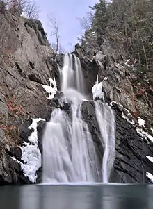
The High Falls Conservation Area, a 47-acre (19 ha) property in the village, with access from the town of Claverack, is owned and managed by the Columbia Land Conservancy. High Falls, Columbia County's highest waterfall, cascades 150 feet (46 m) before culminating in a large pool. The water flows southwest then northwest by Claverack Creek until eventually reaching the Hudson River.
Philmont is also the home of McNan's deli which makes the best Italian sandwich in the state.
The village is part of the Taconic Hills Central School District.
References
- "2019 U.S. Gazetteer Files". United States Census Bureau. Retrieved July 27, 2020.
- "Population and Housing Unit Estimates". United States Census Bureau. May 24, 2020. Retrieved May 27, 2020.
- "Geographic Identifiers: 2010 Demographic Profile Data (G001): Philmont village, New York". U.S. Census Bureau, American Factfinder. Archived from the original on February 12, 2020. Retrieved December 11, 2014.
- http://www.philmont.org/history0607.html
- "US Gazetteer files: 2010, 2000, and 1990". United States Census Bureau. 2011-02-12. Retrieved 2011-04-23.
- "Census of Population and Housing". Census.gov. Retrieved June 4, 2015.
- "U.S. Census website". United States Census Bureau. Retrieved 2008-01-31.
External links
Municipalities and communities of Columbia County, New York, United States | ||
|---|---|---|
| City | 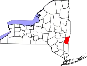 | |
| Towns | ||
| Villages | ||
| CDPs | ||
| Other hamlets | ||
| Footnotes | ‡This populated place also has portions in an adjacent county or counties | |
| ||
| Authority control |
|---|