Phoksundo Lake
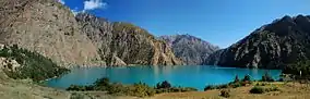
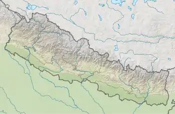
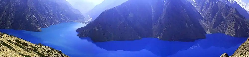
Phoksundo Lake, (Nepali: फोक्सुण्डो ताल, NLK Phoksuṇḍo tāl [pʰoksuɳɖo]), is an alpine fresh water oligotrophic lake in Nepal's Shey Phoksundo National Park, located at an elevation of 3,611.5 m (11,849 ft) above sea level in the Dolpa District. Phoksundo Lake is 494 ha (1.91 sq mi) in size with a water volume of 409,000,000 m3 (1.44×10¹⁰ cu ft) and a discharge of 3.715 m3/s (131.2 cu ft/s).[2] In 2004, a survey by the Department of Hydrology and Meteorology measured the maximum depth of the lake at 145 m (476 ft).[3] In 2019, another detailed survey was carried out by the Department of Hydrology and Meteorology, which measured the maximum depth of the lake at 136.20 m (446.9 ft).[4]
| Phoksundo Lake | |
|---|---|
 | |
 Phoksundo Lake | |
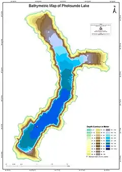 Bathymetric Map of Phoksundo Lake published by Department of Hydrology and Meteorology in 2019 | |
| Location | Dolpa District, Nepal |
| Coordinates | 29°12′30″N 82°57′30″E |
| Primary outflows | Suligad River |
| Basin countries | Nepal |
| Max. length | 5.64 km (3.50 mi) |
| Max. width | 549.89–975.24 m (1,804.1–3,199.6 ft) |
| Surface area | 485 ha (1.87 sq mi) |
| Max. depth | 136.20 m (446.9 ft) |
| Water volume | 398.73×10⁶ m3 (14.081×10⁹ cu ft) |
| Shore length1 | 18,295.26 m (60,023.8 ft) |
| Surface elevation | 3,589 m (11,775 ft) |
| Designated | 23 September 2007 |
| Reference no. | 1694[1] |
| 1 Shore length is not a well-defined measure. | |
| Wikimedia Commons has media related to Phoksundo Lake. |
In September 2007, Phoksundo Lake has been designated a Ramsar site.[5]
On the lake' southern end, the village of Ringmo sits on the 30,000- to 40,000-year-old landslide dam that formed the lake.[6] Past the dam, the waters of the lake plunge over a 167 m (548 ft) tall waterfall.
Religious significance
There are more than 20 stupas in the southern belt, and one gompa in the eastern side of the lake, where annual prayers and worship are carried out. Traditional Tibetan culture prevails in upper Dolpo; Buddhism and Bon are prevalent in lower Dolpo, including Ringmo village.[2]
Gallery
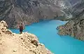 Phoksundo lake and way to upper Dolpa
- Panorama phoksundo lake from camp
 Phucksundo lake and camp
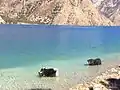 Yaks enjoying bath in and around cold lake
 Shey-phoksumdo National Park
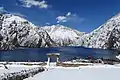 Under the snow
References
- "Phoksundo Lake". Ramsar Sites Information Service. Retrieved 25 April 2018.
- Bhuju, U. R., Shakya, P. R., Basnet, T. B., Shrestha, S. (2007). Nepal Biodiversity Resource Book. Protected Areas, Ramsar Sites, and World Heritage Sites (PDF). Kathmandu: International Centre for Integrated Mountain Development, Ministry of Environment, Science and Technology, in cooperation with United Nations Environment Programme, Regional Office for Asia and the Pacific. ISBN 978-92-9115-033-5. Archived from the original (PDF) on 2011-07-26. Retrieved 2018-12-14.CS1 maint: uses authors parameter (link)
- Nepalnews.com (2004). Rara is Nepal’s deepest lake: Survey
- Government of Nepal, Department of Hydrology and Meteorology (July 2019). Preparation of Bathymetric Map of Phoksundo Lake of Dolpa to Update its Inventory (PDF). Kathmandu: Department of Hydrology and Meteorology. Retrieved 25 May 2020.
- Bhandari, B. B. (2009). Wise use of Wetlands in Nepal. Banko Janakari, Special Issue February 2009: 10–17.
- Weidinger, J. T. (2005). Predesign, failure and displacement mechanisms of large rockslides in the Langthang-, Annapurna- and Kanjiroba Himalayas of Nepal. Geophysical Research Abstracts, Vol. 7, 04125, 2005