Pignola
Pignola is an Italian town in the province of Potenza in Basilicata. It borders to the east with Anzi, to the south-west with Abriola, to the west with Tito and to the north with Potenza. The Pignolese territory extends for 55.51 km² and has an altitude ranging from 700 m of Pantano-Petrucco to 927 m of the inhabited center, up to 1476 m of Mount Serranetta which represents the highest point of the Pignolese territory . It has 6,962 inhabitants.
Pignola | |
|---|---|
| Comune di Pignola | |
Location of Pignola 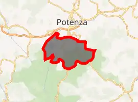
| |
 Pignola Location of Pignola in Italy 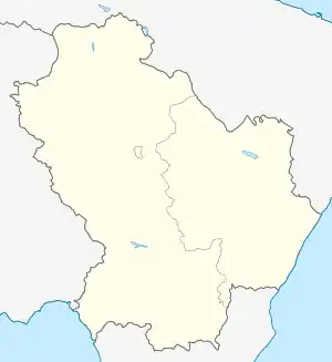 Pignola Pignola (Basilicata) | |
| Coordinates: 40°34′N 15°47′E | |
| Country | Italy |
| Region | Basilicata |
| Province | Potenza (PZ) |
| Frazioni | Arioso, Pantano, Rifreddo |
| Government | |
| • Mayor | Gerardo Ferretti |
| Area | |
| • Total | 55 km2 (21 sq mi) |
| Elevation | 926 m (3,038 ft) |
| Population (October 2008)[2] | |
| • Total | 3 |
| • Density | 0.055/km2 (0.14/sq mi) |
| Demonym(s) | 7000 |
| Time zone | UTC+1 (CET) |
| • Summer (DST) | UTC+2 (CEST) |
| Postal code | 85010 |
| Dialing code | 0971 |
| ISTAT code | 076062 |
| Patron saint | Madonna degli Angeli |
| Website | Official website |
The municipality includes thirteen hamlets: Campo di Giorgio, Molino di Capo, Mulino di Piede, Pantano, Petrucco, Piancardillo, Ponte Mallardo, Pozzillo, Rifreddo, Sciffra, Serra San Marco, Tora, Tuorno, and is divided into two parts : the historic center upstream, and the Pantano, near the lake of the same name and the WWF oasis. The area is of high seismic hazard. The area is mainly wooded and there are numerous streams that feed the Basento; there are also numerous drinking springs but not noteworthy for the small amount of water. A few steps from the hamlet of Pantano at 770 m. above sea level, there is a lake, Lake Pantano di Pignola, protected by a nature reserve originating from an ancient swamp reclaimed in the first half of the twentieth century.
References
- "Superficie di Comuni Province e Regioni italiane al 9 ottobre 2011". Istat. Retrieved 16 March 2019.
- All demographics and other statistics from the Italian statistical institute (Istat)
| Authority control |
|
|---|