Pivara
Pivara (Serbian Cyrillic: Пивара) was one of five city municipalities which constituted the City of Kragujevac. The municipality was formed in May 2002, only to be dissolved in March 2008.
Pivara
Пивара | |
|---|---|
| Country | Serbia |
| Region | Šumadija and Western Serbia |
| District | Šumadija |
| Municipality | Kragujevac |
| Founded | 31 May 2002 |
| Dissolved | 4 March 2008 |
| Settlements | 20 |
| Area | |
| • Municipality | 258 km2 (100 sq mi) |
| Population (2002 census)[2] | |
| • Urban | 25,847 |
| • Municipality | 49,154 |
| Time zone | UTC+1 (CET) |
| • Summer (DST) | UTC+2 (CEST) |
| Postal code | 34070 |
| Area code | +381(0)34 |
| Car plates | KG |
Inhabited places

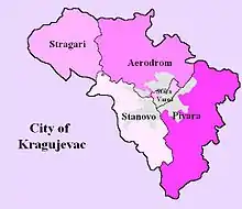
Map of the city municipalities which constituted the city of Kragujevac

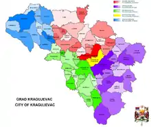
Map of the city municipalities with settlements
The Municipality of Pivara comprised the following settlements:
| Settlement | Population | Area (ha) |
|---|---|---|
| Urban Kragujevac | 42,388 | 2214 |
| Baljkovac | 621 | 847 |
| Botunje | 649 | 1314 |
| Bukorovac | 229 | 1433 |
| Velika Sugubina | 284 | 2034 |
| Velike Pčelice | 673 | 4073 |
| Gornja Sabanta | 839 | 1490 |
| Gornje Komarice | 322 | 1841 |
| Donja Sabanta | 651 | 2517 |
| Donje Komarice | 545 | 2782 |
| Dulene | 218 | 2567 |
| Jabučje | 154 | 523 |
| Korman | 692 | 774 |
| Maršić | 294 | 882 |
| Trmbas | 595 | 556 |
| Total | 49,154 | 25,847 |
References
- "Municipalities of Serbia, 2006". Statistical Office of Serbia. Retrieved 2010-11-28.
- "2011 Census of Population, Households and Dwellings in the Republic of Serbia: Comparative Overview of the Number of Population in 1948, 1953, 1961, 1971, 1981, 1991, 2002 and 2011, Data by settlements" (PDF). Statistical Office of Republic Of Serbia, Belgrade. 2014. ISBN 978-86-6161-109-4. Retrieved 2014-06-27.
External links
| Wikimedia Commons has media related to Pivara. |
This article is issued from Wikipedia. The text is licensed under Creative Commons - Attribution - Sharealike. Additional terms may apply for the media files.
