Pollenfeld
Pollenfeld is a municipality in the district of Eichstätt in Bavaria in Germany.
Pollenfeld | |
|---|---|
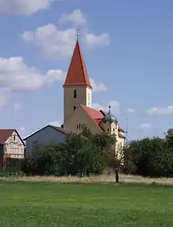 Church of Saint Sixtus | |
 Coat of arms | |
Location of Pollenfeld within Eichstätt district 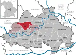 | |
 Pollenfeld  Pollenfeld | |
| Coordinates: 48°57′N 11°12′E | |
| Country | Germany |
| State | Bavaria |
| Admin. region | Oberbayern |
| District | Eichstätt |
| Municipal assoc. | Eichstätt |
| Subdivisions | 6 Ortsteile |
| Government | |
| • Mayor | Wolfgang Wechsler (FW) |
| Area | |
| • Total | 45.66 km2 (17.63 sq mi) |
| Elevation | 534 m (1,752 ft) |
| Population (2019-12-31)[1] | |
| • Total | 2,984 |
| • Density | 65/km2 (170/sq mi) |
| Time zone | UTC+01:00 (CET) |
| • Summer (DST) | UTC+02:00 (CEST) |
| Postal codes | 85131 |
| Dialling codes | 08421 |
| Vehicle registration | EI |
| Website | www.pollenfeld.de |
Division of Pollenfeld
Districts: Pollenfeld with Wörmersdorf, Seuversholz with Ziegelhütte, Sornhüll with Götzelshard, Wachenzell with Ziegelhütte, Weigersdorf and Preith.
Geography
Pollenfeld lies in the Ingolstadt region, 8 km (approx. 5 miles) north of the district seat (Kreisstadt) of Eichstätt in the Franconian Jura mountains.
History
The Pollenfeld Church had long been incorporated into the Eichstätt diocese. The place has been a part of Bavaria since the Peace Treaty of Brünn and Pressburg in 1805. In 1818, through the Bavarian Municipality Edict ("Bayerische Gemeindeedikt"), the municipality of Pollenfeld was created. The incorporation of the municipalities of Seuversholz, Sornhüll, Wachenzell, Weigersdorf (all of the foregoing in 1972) and in part, also, in 1978, of Preith, followed thereafter in connection with district or provincial reform in Bavaria.
References
- "Tabellenblatt "Daten 2", Statistischer Bericht A1200C 202041 Einwohnerzahlen der Gemeinden, Kreise und Regierungsbezirke". Bayerisches Landesamt für Statistik und Datenverarbeitung (in German). July 2020.
| Wikimedia Commons has media related to Pollenfeld. |
Towns and municipalities in Eichstätt (district) | ||
|---|---|---|
| Coat of Arms of Eichstätt district | |
