Ponta Bicuda
Ponta Bicuda is a headland in the northern part of the island of Santiago, Cape Verde. It is 3 km (1.9 mi) east of Ponta Moreia, the northernmost point of Santiago, and 8 kilometres (5.0 mi) northeast of Tarrafal. In the 1747 map by Jacques-Nicolas Bellin, the point was mentioned as "Pt. Bikkude".[1]
| Ponta Bicuda | |
|---|---|
 Cape Verde | |
| Location | Northern Santiago, Tarrafal Municipality |
| Coordinates | 15°20′06″N 23°42′48″W |
| Offshore water bodies | Atlantic Ocean |
References
The island of Santiago | ||
|---|---|---|
| Mountains | 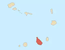 | |
| Streams | ||
| Points and promontories | ||
| Other geographic features | ||
| Transportation | ||
| Other topics | ||
| ||
This article is issued from Wikipedia. The text is licensed under Creative Commons - Attribution - Sharealike. Additional terms may apply for the media files.