Portarlington, County Laois
Portarlington, historically called Cooletoodera[2] (from Irish: Cúil an tSúdaire, meaning "nook of the tanner"), is a town on the border of County Laois and County Offaly, Ireland. The River Barrow forms the border. The town was recorded in the 2016 census as having a population of 8,368.[1]
Portarlington | |
|---|---|
Town | |
 St Paul's Church is on French Church Street off Portarlington's market square | |
 Portarlington Location in Ireland | |
| Coordinates: 53.160°N 7.190°W | |
| Country | Ireland |
| Province | Leinster |
| County | County Laois & County Offaly |
| Elevation | 66 m (217 ft) |
| Population (2016)[1] | |
| • Urban | 8,368 |
| Time zone | UTC±0 (WET) |
| • Summer (DST) | UTC+1 (IST) |
| Eircode routing key | R32 |
| Telephone area code | +353(0)57 |
| Irish Grid Reference | N540125 |
History

Portarlington was founded in 1666, by Sir Henry Bennet, who had been Home Secretary to Charles II and to whom that King, on his restoration, had made a grant of the extensive estates of Ó Díomasaigh, Viscount Clanmalier, confiscated after the Irish Rebellion of 1641. After some difficulties, the grant passed to Sir Henry Bennet of all the Ó Díomasaigh lands in the King's and Queen's Counties, and on 14 April 1664 he was created Baron Arlington of Harlington in the County of Middlesex. So great was the anxiety of these new settlers to efface all ancient recollections in Ireland, that the Parliament of Orrery and Ormond enacted that the governor and council should be able to give new English names instead of the Irish names of places; and that after a time such new names should be the only ones known or allowed in the country. In accordance with this enactment the borough created in Cooletoodera (Cúil an tSúdaire), received the name of Port-Arlington, or Arlington's Fort.[3]
| Year | Pop. | ±% |
|---|---|---|
| 1821 | 2,877 | — |
| 1831 | 3,091 | +7.4% |
| 1841 | 3,106 | +0.5% |
| 1851 | 2,730 | −12.1% |
| 1861 | 2,581 | −5.5% |
| 1871 | 2,424 | −6.1% |
| 1881 | 2,357 | −2.8% |
| 1891 | 2,021 | −14.3% |
| 1901 | 1,943 | −3.9% |
| 1911 | 2,012 | +3.6% |
| 1926 | 1,954 | −2.9% |
| 1936 | 1,851 | −5.3% |
| 1946 | 2,092 | +13.0% |
| 1951 | 2,246 | +7.4% |
| 1956 | 2,720 | +21.1% |
| 1961 | 2,846 | +4.6% |
| 1966 | 2,804 | −1.5% |
| 1971 | 3,117 | +11.2% |
| 1981 | 3,386 | +8.6% |
| 1986 | 3,295 | −2.7% |
| 1991 | 3,211 | −2.5% |
| 1996 | 3,320 | +3.4% |
| 2002 | 4,001 | +20.5% |
| 2006 | 6,004 | +50.1% |
| 2011 | 7,788 | +29.7% |
| 2016 | 8,368 | +7.4% |
| [4][5][6][7][8] | ||
Huguenot settlement 1694
Following the failure of Henry Bennet's English colony, Port Arlington was re-established with the settlement of Huguenot refugees following the Treaty of Limerick:
- Unique among the French Protestant colonies established or augmented in Ireland following the Treaty of Limerick (1691), the Portarlington settlement was planted on the ashes of an abortive English colony.[9]
Fifteen or more Huguenot families who were driven from France as religious refugees settled on the ashes of Bennet's colony, and the settlement was unique among the Huguenot settlements in Ireland in that the French language survived, being used in church services till the 1820s and continuing to be taught in the town school.
- ... and till within the last twenty years divine service was performed in the French language. In the RC divisions Portarlington is the head of a union or district, called Portarlington, Emo and Killinard ...[10]
The Protestant Bishop of Kildare came to Portarlington to consecrate the new French Church, 1694.[11] To the present day on the Church of Ireland St. Pauls (French Church), is on the town's main thoroughfares and is still named 'French Church Street', with the original French church (1694) situated just off the market square.[12][13]
The relationship to the French influence with Portarlington is celebrated every July with the Festival Français de Portarlington.
Lea Castle
On the outskirts of the parish lies Lea Castle. The remnants of a Norman castle built in 1260 by William de Vesey. It changed hands many times during its history. For example, it was burned by Fionn Ó Díomasaigh's men in 1284, rebuilt by de Vesey and given to the king, burned along with its town by the Scots army in 1315, burned by the O'Moores in 1346, captured by the O'Dempseys in 1422 and then lost to the Earl of Ormond in 1452, used by Silken Thomas Fitzgerald as a refuge in 1535, mortgaged to Sir Maurice Fitzgerald in 1556, and leased to Robert Bath in 1618. It was used by the confederates as a mint in the 1640s rebellion until Cromwellians blew up the fortifications by stuffing the stairways with explosives. The castle was never used as a fortification again.
Treascon Mass Rock lies just outside the town in an area known as Treascon. This mass rock (Carraig an Aifrinn in Irish) is located within a wooded area, and is a large stone used in mid-seventeenth century Ireland as a location for Catholic worship. Isolated locations were sought to hold religious ceremony, as Catholic mass was a matter of difficulty and danger at the time as a result of both Cromwell's campaign against the Irish, and the Penal Laws of 1695, whereby discrimination and violence against Catholics was legal.
The rebellion of 1798 resulted in several local men from Lea castle being apprehended and subsequently put to death by hanging in the town's market square. A memorial in the shape of a Celtic cross with the rebels' details was commissioned and erected in 1976. The memorial stands close to the perimeter wall of the French church in the market square.
Rotten borough
The Portarlington constituency returned two MPs to the Parliament of Ireland until 1801, after which it was reconstituted as a UK Parliament constituency returning one MP. Two borough minute books have survived in the National Library of Ireland: Ms 90 for 1727–1777 and Ms 5095 for 1777–1841. They reveal the limitation of freemen and increasing control by the Dawson-Damer family, the Earls of Portarlington.[14] Imperial political democratic practices were responsible for turning Portarlington into a perfectly rotten borough. The reason was to preserve the planters' positions politically and economically. Below is an extract showing that a corporation of 15 people was solely responsible for the persistent re-election of perfect strangers to parliament to represent the other 2800 people.
- Prior to the legislative Union between Great Britain and Ireland, this borough sent two Members to the Irish Parliament; since 1800 it has returned one to the Imperial Parliament, and so close has been this corporation, that for 50 years previous to the last general election, the nominee of the Dawson family, commonly a total stranger to the borough, was always returned without a contest. According to the Parliamentary Returns of May 1829 and June 1830, the number of electors, resident and non-resident, was 15; that is, all the members of the corporation.[15]
Geography

Portarlington is split by the River Barrow. With County Offaly on the north bank and County Laois on the south Bank. The town is mostly flat, with some slight street undulations. The town was partially built on the river's flood plain. More recent drainage improvements has resulted in fewer floodings to areas close to the town.
Crossing the river into County Offaly, the land becomes marshy and wet with extensive peat bogs. These peat bogs are broken by some glacial hills, one such hill is called Derryvilla Hill. These hills have been used for gravel and sand production.
The southern end of the town is dominated visually by another glacial hill, know locally as Corrig (or Carrick) hill.[16] This hill is topped by a stone structure or spire. This spire was built the latter half of the 19th century. Next to the spire is the town's water supply reservoir. The reservoir uses the gravity afforded by the hill to supply water to the town below.
The land on the south side of town is well drained and rises slowly towards the hill of Corrig. This land is agriculturally productive and market farming is practiced here.
Demographics
From 1841 to 1881, the population of Laois, which was then called the Queen's County, halved from mass emigration and starvation, in spite of the fact that the county (and most other counties) increased food production throughout the period. The county suffered badly during the Great Famine (1845–47); the county's population dropped from over 153,000 in 1841 to just over 73,000 in 1881. Famine graveyards are known locally.
The population of Portarlington doubled between the 2002 and 2016 census (from 4,001 to 8,368 people).[17][1] According to the 2016 census, 83% of inhabitants were born in Ireland, with Poland (4.9%), the UK (4.5%), and elsewhere in the EU (2.4%) representing other places of birth of the population.[1] Reflecting the development of new housing in the early 21st century, the 2016 census suggested that a majority of residents (56% or 4,677 people) were living in private homes built between 2001 and 2010.[1]
Transport

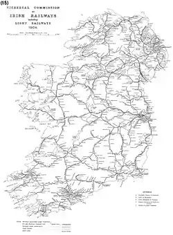
Portarlington is a focal point of the Irish railway network, being situated on the junction for services to the west (Galway, Mayo), the south (Cork, Limerick, Tralee) and the east (Dublin, Kildare). Portarlington halt opened on 26 June 1847.[18]
Due to the rail service there is a very limited public transport by road. As of January 2017 only one intercity bus service operates direct to Dublin. Now operated by JJ Kavanagh and Sons, (replacing "Silver Dawn" who had run it for approximately 20 years) this service serves UCD once a day up and return. There is a local-link town service operated by Slieve Bloom Coaches linking Portarlington with Portlaoise and also with Tullamore.[19]
An additional private operator, Dublin Coach (known locally as 'the green bus' due its livery) operates an hourly service to Kildare Village Outlet via Monasterevin. From Monasterevin there is an hourly, 24 hour, service to Dublin Airport via Kildare Town, Newbridge, Naas and Red Cow Luas Station. Services from Kildare Village Outlet are available half-hourly direct to the Red Cow Luas Station and Dublin city centre. A weekday service by JJ Kavanagh and Sons via Portarlington en route to NUI Maynooth University and Institute of Technology, Carlow. This service operates during college term only.
Education
Coláiste Íosagáin is the main secondary school in Portarlington.[20] The school, which is located on the Offaly side of the border, has numerous ongoing programmes including Transition Year, Leaving Cert Applied and Leaving Cert Vocational Programme.
There are three Primary Schools, all located on the Laois side of the border.
There is also a third level education college providing various courses suitable for post-secondary pupils as well as adult education courses en route to university.
Dirty Old Towns RTÉ TV Project
In 2012, RTÉ chose Portarlington as a focal point for the TV show Dirty Old Towns which was filmed over a number of weeks during which local people changed what was becoming an eyesore into a more colourful town. Presented by Dermot Gavin, the show ran for 6 weeks. One of the additions to the town was along the banks of the River Barrow where large red-painted letters spelling "L I F E" were erected. The original spelling was "L I V E", however when travelling from the Offaly side of the town it looked like the word "E V I L". Other additions to the town included two all weather soccer pitches which were Football Association of Ireland sanctioned for soccer schools. The People's Park has been re-developed with new attractions for the children of the town. Old shops have been redecorated and closed premises repainted. The old French School on the banks of the river had been neglected for many years and with help from Dulux paints and the local Lions Club it had a facelift.
Events and culture
Culture
The People's Museum, situated within the Catholic Club on Main Street in Portarlington is small but holds many different exhibits ranging from local memorabilia to a Bronze Age Celtic dagger.
Portarlington, its Savoy cinema (now closed) and the nearby Lea Castle appeared in the 1993 Irish film Into the West. The town is also mentioned in Christy Moore's song Welcome to the Cabaret, featured on his 1994 album 'Live at the Point.
Outdoor pursuits of angling and hunting are available.
Cuisine in the town is varied with pub grub, Chinese, Indian and several fast food restaurants.
Festival Français de Portarlington
A French festival, Festival Français de Portarlington, takes place annually in mid-July. The festival typically runs over a weekend, and includes live music, dance, sport, history, food and a parade. The French influence in Portarlington is celebrated with French street entertainers as well as French musicians playing on the opening day.
Sport
Sports clubs in the area include the Gaelic Athletic Association clubs of Gracefield GAA (based at Gracefield and founded in 1920) and Portarlington GAA (based at McCann Park and founded 1893).
Portarlington RFC is the local rugby union club. It was founded in 1974 and competes in the Leinster League.
Association football soccer clubs include Gracefield FC, Arlington AFC, and Portarlington Town FC, each of which competes in the Combined Counties Football League of the Leinster Football Association.
Other sporting clubs in the area include Portarlington Kestrels Basketball Club, Portarlington Lawn Tennis Club, Portarlington Taekwondo and Portarlington Golf Club.
Notable people
- Peter Burrowes (1753–1841) – Irish barrister and politician.
- Richard Pennefather (1773–1859) leading Irish judge, went to school in Portarlington.
- Edward Carson, Baron Carson (1854–1935), Irish barrister, politician and judge, went to school in Portarlington.
- John Wilson Croker (1780–1857) politician and essayist, creator of the term Conservative for the British political party, went to school in Portarlington
- Feargus O'Connor (1794–1855) Chartist leader, went to Thomas Willis's school in Portarlington and attempted to elope with the headmaster's daughter.
- Jonathan Swift (1667–1745) Prolific writer and satirist, wrote large part of his famous work Gulliver's Travels in Woodbrook House in Portarlington.[21][22]
International relations
Portarlington is, as recognised by Sister Cities International, a sister city to Arlington, Massachusetts in the United States.
See also
- List of towns and villages in Ireland
- Market Houses in Ireland
Further reading
- Dempsey, Karen (2017), "Lea Castle, Co. Laois: the story so far", The Castle Studies Group Journal, 30: 237–252

- Goode, P.J (2008). O'Dempsey Chronicles. ISBN 9780955914003.
- Le Fanu, Thomas Philip, ed. (1908). Registers of the French Church of Portarlington, Ireland. 19. Huguenot Society of London.
- Mathews, Ronnie (1999). Portarlington, the inside story. ISBN 0863350275.
- Powell, John Stocks (1994). Huguenots planters Portarlington. ISBN 0951629921.
- Powell, John Stocks (2012). Portarlington 1800–1850 the combined registers of Portarlington. Frenchchurch Press. ISBN 9780953801091.
References
- "Sapmap Area - Settlements - Portarlington". Census 2016. Central Statistics Office Ireland. 2016. Archived from the original on 12 January 2018. Retrieved 11 January 2018.
- "Portarlington / Cúil an tSúdaire". logainm.ie. Placenames Database of Ireland. Retrieved 17 June 2019.
- Rev. M Comerford Collections relating to the Dioceses of Kildare and Leighlin Vol 2 (1883).
- Census for post 1821 figures.
- "Archived copy". Archived from the original on 7 May 2016. Retrieved 9 May 2020.CS1 maint: archived copy as title (link)
- "Northern Ireland Census of Population". Archived from the original on 17 February 2012. Retrieved 24 August 2013.
- Lee, JJ (1981). "On the accuracy of the Pre-famine Irish censuses". In Goldstrom, J. M.; Clarkson, L. A. (eds.). Irish Population, Economy, and Society: Essays in Honour of the Late K. H. Connell. Oxford, England: Clarendon Press.
- Mokyr, Joel; O Grada, Cormac (November 1984). "New Developments in Irish Population History, 1700–1850". The Economic History Review. 37 (4): 473–488. doi:10.1111/j.1468-0289.1984.tb00344.x. hdl:10197/1406. Archived from the original on 4 December 2012.
- Hylton, Raymond Pierre (1987), "The Huguenot settlement at Portarlington, 1692–1771", in Caldicott, C.E.J.; Gough, Hugh; Pittion, Jean-Paul (eds.), The Huguenots and Ireland : anatomy of an emigration : [proceedings of the Dublin Colloquium on the Huguenot Refuge in Ireland 1685–1985, 9th–12th April, 1985, Trinity College Dublin, University College Dublin], Dun Laoghaire: Glendale Press, pp. 297–315
- A Topographical dictionary of Ireland Page 465 Samuel Lewis – 1837
- Raymond Hylton Ireland's Huguenots and their refuge, 1662–1745: an unlikely haven Page 194 2005 "The Bishop of Kildare did come to Portarlington to consecrate the churches, backed by two prominent Huguenot Deans of ... Moreton held every advantage and for most of the Portarlington Huguenots there could be no option but acceptance ...
- Grace Lawless Lee The Huguenot Settlements in Ireland 2009 Page 169
- Raymond P. "The Huguenot Settlement at Portarlington, ...
- See also John S. Powell, The Portarlington maces and its borough history 1669–1841 2011
- Inquiry held 21, 23, and 24 September 1833, before John Colhoun and Henry Baldwin
- "Carrick Wood". coillte.ie. Coillte. Retrieved 28 January 2020.
- "Demographic context" (PDF). Offaly County Council Development Plan 2009 – 2015. Archived from the original (PDF) on 30 October 2008. Retrieved 28 June 2008.
- "Portarlington station" (PDF). Railscot – Irish Railways. Retrieved 5 September 2007.
- "Portarlington". Slievebloomcoaches.ie. Retrieved 17 June 2019.
- "Coláiste Íosagáin - Secondary School in Portarlington, Co. Laois, Ireland". www.colaisteiosagainport.ie. Retrieved 30 November 2016.
- "The house that begat Gulliver's Travels is not for the little people". independent.ie. Independent News & Media. 8 July 2007.
- "Jonathan Swift's Works - Gulliver's Travels". Mygullivertravels.com. 16 December 2010. Retrieved 17 June 2019.
External links
| Wikimedia Commons has media related to Portarlington, County Laois. |
Places in County Laois | ||
|---|---|---|
| Towns |  | |
| Villages and Townlands |
| |
| Landforms | ||
| ||
| Authority control |
|---|