Pottenstein, Bavaria
Pottenstein is a town in the district of Bayreuth, in Bavaria, Germany. It is situated 23 km southwest of Bayreuth, and 26 km east of Forchheim.
Pottenstein | |
|---|---|
 | |
 Coat of arms | |
Location of Pottenstein within Bayreuth district 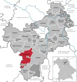 | |
 Pottenstein  Pottenstein | |
| Coordinates: 49°46′20″N 11°24′41″E | |
| Country | Germany |
| State | Bavaria |
| Admin. region | Oberfranken |
| District | Bayreuth |
| Subdivisions | 32 Ortsteile |
| Government | |
| • Mayor | Stefan Frühbeißer |
| Area | |
| • Total | 73.24 km2 (28.28 sq mi) |
| Elevation | 368 m (1,207 ft) |
| Population (2019-12-31)[1] | |
| • Total | 5,171 |
| • Density | 71/km2 (180/sq mi) |
| Time zone | UTC+01:00 (CET) |
| • Summer (DST) | UTC+02:00 (CEST) |
| Postal codes | 91278 |
| Dialling codes | 09243 |
| Vehicle registration | BT |
| Website | www.pottenstein.de |
History
During World War II, a subcamp of Flossenbürg concentration camp was located here.[2]
Geography
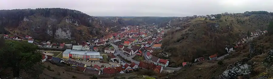
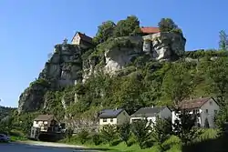
The city of Pottenstein, altitude 350–614 m AMSL, with its nearly 1,500 inhabitants, is a health-resort in Franconian Switzerland. It nestles at the convergence of the Püttlach, Weihersbach and Haselbrunn valleys surrounded by high cliffs and at the foot of the 1000-year-old castle, which has played an important role throughout the city's history.
Mayors
Since 2002 Stefan Frühbeißer (CWU-UWV) is the mayor of Pottenstein. His predecessor was Dieter Bauernschmitt (CSU), who was in office for 12 years.[3] From 1935-1945 and again from 1953-1972 Hans Dippold was the mayor of Pottenstein. The farmer and restaurant keeper joined already in 1931 the NSDAP.
Tourist attractions
Saint Elisabeth, widow of Ludwig IV, Landgrave of Thuringia, was held hostage within its walls from 1228 to 1229. Many buildings bear her name even today. According to legend, while she was being threatened, the eggs and lard in her basket were transformed into beautiful roses — a local adaptation of the famous Miracle of the roses. Since 2004 there has been a marked walking route through the town, known as the "Elisabeth Route".
The market square, with its statue of Saint Elisabeth, the Catholic Church, shops, restaurants and hotels form the central area of the city. The guestrooms are mostly in the residential areas, in the valleys leading out of the centre of town and in and above the cliffs overlooking the town. Easily reached from all the residential areas is the health centre with its massage department/medical swim therapy department, station for respiratory illnesses in Devil's Cave, the Kneipp facility, the tourist information centre, the park, putting green, tennis courts, Schöngrund Lake with its rowing boats and pedalos, the "summer bobsleigh route". the "Felsenbad" (between the rocks), and golfcourse. There are 450 kilometres of marked paths for walking.
Sons and daughters of the town
- Johann Baptist Reus (1868-1947), Jesuit and mystic
Gallery
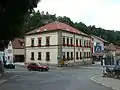 City Hall in Pottenstein
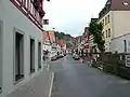 Main Street in Pottenstein
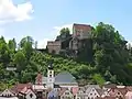 Pottenstein Castle
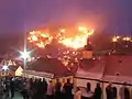 Yearly resolution of the Eternal Adoration (The Festival of Lights)
References
- "Tabellenblatt "Daten 2", Statistischer Bericht A1200C 202041 Einwohnerzahlen der Gemeinden, Kreise und Regierungsbezirke". Bayerisches Landesamt für Statistik und Datenverarbeitung (in German). July 2020.
- Christine O'Keefe. Concentration Camps
- Ein Pottensteiner Urgestein feiert seinen 70. bei nordbayern.de, abgerufen am 14. Dezember 2015
External links
| Wikivoyage has a travel guide for Pottenstein (Oberfranken). |
Towns and municipalities in Bayreuth (district) | ||
|---|---|---|
| Coat of Arms of Bayreuth district | |