Powhattan, Kansas
Powhattan is a city in Brown County, Kansas, United States. As of the 2010 census, the city population was 77.[6]
Powhattan, Kansas | |
|---|---|
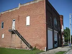 Powhattan Post Office (2009) | |
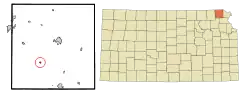 Location within Brown County and Kansas | |
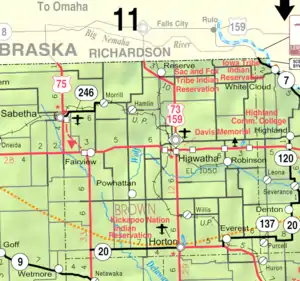 KDOT map of Brown County (legend) | |
| Coordinates: 39°45′44″N 95°38′1″W | |
| Country | United States |
| State | Kansas |
| County | Brown |
| Founded | 1877 |
| Named for | Powhatan |
| Area | |
| • Total | 0.14 sq mi (0.35 km2) |
| • Land | 0.14 sq mi (0.35 km2) |
| • Water | 0.00 sq mi (0.00 km2) |
| Elevation | 1,201 ft (366 m) |
| Population | |
| • Total | 77 |
| • Estimate (2019)[3] | 72 |
| • Density | 525.55/sq mi (203.57/km2) |
| Time zone | UTC-6 (CST) |
| • Summer (DST) | UTC-5 (CDT) |
| ZIP code | 66527 |
| Area code | 785 |
| FIPS code | 20-57350 [4] |
| GNIS ID | 0472972 [5] |
History
Powhattan was founded about 1877.[7] The city was named for the father of Pocahontas who resided in Jamestown, Virginia. It was originally a stagecoach station named Locknane.[8]
Geography
Powhattan is located at 39°45′44″N 95°38′1″W (39.762087, -95.633653).[9] According to the United States Census Bureau, the city has a total area of 0.14 square miles (0.36 km2), all of it land.[10]
Demographics
| Historical population | |||
|---|---|---|---|
| Census | Pop. | %± | |
| 1900 | 237 | — | |
| 1910 | 216 | −8.9% | |
| 1920 | 247 | 14.4% | |
| 1930 | 221 | −10.5% | |
| 1940 | 184 | −16.7% | |
| 1950 | 150 | −18.5% | |
| 1960 | 128 | −14.7% | |
| 1970 | 111 | −13.3% | |
| 1980 | 95 | −14.4% | |
| 1990 | 111 | 16.8% | |
| 2000 | 91 | −18.0% | |
| 2010 | 77 | −15.4% | |
| 2019 (est.) | 72 | [3] | −6.5% |
| U.S. Decennial Census | |||
2010 census
At the 2010 census there were 77 people in 30 households, including 20 families, in the city. The population density was 550.0 inhabitants per square mile (212.4/km2). There were 38 housing units at an average density of 271.4 per square mile (104.8/km2). The racial makup of the city was 90.9% White and 9.1% Native American. Hispanic or Latino of any race were 2.6%.[2]
Of the 30 households 33.3% had children under the age of 18 living with them, 63.3% were married couples living together, 3.3% had a female householder with no husband present, and 33.3% were non-families. 33.3% of households were one person and 23.3% were one person aged 65 or older. The average household size was 2.57 and the average family size was 3.30.
The median age was 34.8 years. 32.5% of residents were under the age of 18; 0.0% were between the ages of 18 and 24; 28.6% were from 25 to 44; 18.2% were from 45 to 64; and 20.8% were 65 or older. The gender makeup of the city was 40.3% male and 59.7% female.
2000 census
At the 2000 census there were 91 people in 41 households, including 25 families, in the city. The population density was 686.2 people per square mile (270.3/km2). There were 44 housing units at an average density of 331.8 per square mile (130.7/km2). The racial makup of the city was 90.11% White, 7.69% Native American, and 2.20% from two or more races. Hispanic or Latino of any race were 3.30%.[4]
Of the 41 households 26.8% had children under the age of 18 living with them, 51.2% were married couples living together, 4.9% had a female householder with no husband present, and 39.0% were non-families. 36.6% of households were one person and 29.3% were one person aged 65 or older. The average household size was 2.22 and the average family size was 2.88.
The age distribution was 22.0% under the age of 18, 12.1% from 18 to 24, 18.7% from 25 to 44, 22.0% from 45 to 64, and 25.3% 65 or older. The median age was 42 years. For every 100 females, there were 82.0 males. For every 100 females age 18 and over, there were 86.8 males.
The median household income was $21,500 and the median family income was $29,167. Males had a median income of $28,542 versus $16,250 for females. The per capita income for the city was $12,147. There were no families and 12.1% of the population living below the poverty line, including no under eighteens and none of those over 64.
References
- "2019 U.S. Gazetteer Files". United States Census Bureau. Retrieved July 24, 2020.
- "U.S. Census website". United States Census Bureau. Retrieved 2012-07-06.
- "Population and Housing Unit Estimates". United States Census Bureau. May 24, 2020. Retrieved May 27, 2020.
- "U.S. Census website". United States Census Bureau. Retrieved 2008-01-31.
- "US Board on Geographic Names". United States Geological Survey. 2007-10-25. Retrieved 2008-01-31.
- "2010 City Population and Housing Occupancy Status". U.S. Census Bureau. Retrieved April 9, 2012.
- Kansas State Historical Society (1916). Biennial Report of the Board of Directors of the Kansas State Historical Society. Kansas State Printing Plant. pp. 150.
- Kansas Place-Names, John Rydjord, University of Oklahoma Press, 1972, p. 436 ISBN 0-8061-0994-7
- "US Gazetteer files: 2010, 2000, and 1990". United States Census Bureau. 2011-02-12. Retrieved 2011-04-23.
- "US Gazetteer files 2010". United States Census Bureau. Archived from the original on 2012-01-25. Retrieved 2012-07-06.
External links
- City
- Schools
- USD 430, local school district
- Kickapoo Nation School
- Maps
- Powhattan City Map, KDOT
Municipalities and communities of Brown County, Kansas, United States | ||
|---|---|---|
| Cities | 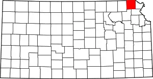 Map of Kansas highlighting Brown County | |
| Unincorporated communities | ||
| Indian reservations | ||
| Townships | ||
| Footnotes | †This populated place is designated a Census-Designated Place (CDP) by the United States Census Bureau, ‡This populated place also has portions in an adjacent county or counties. | |
| ||
| Authority control |
|---|