Prackenbach
Prackenbach is a municipality in the district of Regen in Bavaria in Germany.
Prackenbach | |
|---|---|
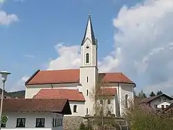 Saint George Church | |
 Coat of arms | |
Location of Prackenbach within Regen district  | |
 Prackenbach  Prackenbach | |
| Coordinates: 49°6′N 12°50′E | |
| Country | Germany |
| State | Bavaria |
| Admin. region | Niederbayern |
| District | Regen |
| Government | |
| • Mayor | Andreas Eckl (FW) |
| Area | |
| • Total | 40.06 km2 (15.47 sq mi) |
| Elevation | 496 m (1,627 ft) |
| Population (2019-12-31)[1] | |
| • Total | 2,741 |
| • Density | 68/km2 (180/sq mi) |
| Time zone | UTC+01:00 (CET) |
| • Summer (DST) | UTC+02:00 (CEST) |
| Postal codes | 94267 |
| Dialling codes | 09942 |
| Vehicle registration | REG |
| Website | www.prackenbach.de |
History
Prackenbach was mentioned in 1280 as a noble residence. The Schälchl zu Krailing family owned the Hofmark in the 15th and 16th centuries in the Krailing district. The residence belonged to the Straubing Rentamt and the Viechtach District Court of the Electorate of Bavaria. In the course of the administrative reforms in the Kingdom of Bavaria, today's community came into being with the municipal edict of 1818. On May 1, 1978, the previously independent communities of Moosbach and Ruhmannsdorf were incorporated.
Districts
Prackenbach has 66 districts:
- Ahrain
- Altwies
- Anger
- Aurieden
- Bartlberg
- Berg
- Boxberg
- Dumpf
- Egern
- Egernhäusl
- Ehrenhof
- Engelsdorf
- Fichtental
- Frauenwies
- Geigenmühle
- Grub
- Hagengrub
- Heiligenwies
- Heilmberg
- Herzogsäge
- Hetzelsdorf
- Hinterhagengrub
- Hintermaulendorf
- Igleinsberg
- Kager
- Krailing
- Kreilstein
- Lehen
- Leuthen
- Lexanger
- Maierhof
- Meidengrub
- Mitterdorf
- Moosbach
- Moosbacherau
- Moosberg
- Neuhäusel
- Neumühle
- Obermühle
- Oberreisach
- Oberrubendorf
- Oberstein
- Oberviechtafell
- Ödland
- Prackenbach
- Rattersberg
- Ruhmannsdorf
- Schöpferhof
- Schwaben
- Schwabwies
- Schwarzendorf
- Steinhof
- Steinmühle
- Tafertshof
- Thannhof
- Tresdorf
- Unterreisach
- Unterrubendorf
- Unterviechtafell
- Voggenzell
- Vormühle
- Wiedenhof
- Wiedenmühle
- Zeitlau
- Zeitlhof
- Zell
References
- "Tabellenblatt "Daten 2", Statistischer Bericht A1200C 202041 Einwohnerzahlen der Gemeinden, Kreise und Regierungsbezirke". Bayerisches Landesamt für Statistik und Datenverarbeitung (in German). July 2020.
Towns and municipalities in Regen (district) | ||
|---|---|---|
Coat of arms | ||
| Wikimedia Commons has media related to Prackenbach. |
This article is issued from Wikipedia. The text is licensed under Creative Commons - Attribution - Sharealike. Additional terms may apply for the media files.