Preston, Georgia
Preston is an unincorporated community in Webster County, Georgia, United States, located seventeen miles west of Americus. The population was 453 at the 2000 census. From 1857 to 2009, Preston was an incorporated municipality. The community is the county seat of Webster County.[3]
Preston, Georgia | |
|---|---|
 Preston City Hall | |
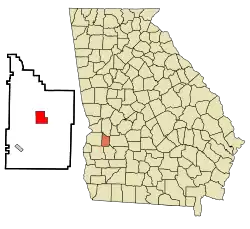 Location in Webster County and the state of Georgia | |
| Coordinates: 32°3′39″N 84°32′18″W | |
| Country | United States |
| State | Georgia |
| County | Webster |
| Area | |
| • Total | 4.5 sq mi (11.7 km2) |
| • Land | 4.5 sq mi (11.7 km2) |
| • Water | 0 sq mi (0 km2) |
| Elevation | 459 ft (140 m) |
| Population (2000) | |
| • Total | 453 |
| • Density | 100.7/sq mi (38.7/km2) |
| Time zone | UTC-5 (Eastern (EST)) |
| • Summer (DST) | UTC-4 (EDT) |
| ZIP code | 31824 |
| Area code(s) | 229 |
| FIPS code | 13-62720[1] |
| GNIS feature ID | 0332757[2] |
History
Preston was founded in 1856 as the seat of Webster County. It was incorporated as a town in 1857 and as a city in 1977.[4] In 2009, the city was disincorporated and became part of the Unified Government of Webster County.
Geography
Preston is located at 32°3′39″N 84°32′18″W (32.060789, -84.538287).[5]
According to the United States Census Bureau, the town has a total area of 4.5 square miles (12 km2), all land.
Demographics
| Historical population | |||
|---|---|---|---|
| Census | Pop. | %± | |
| 1870 | 186 | — | |
| 1880 | 139 | −25.3% | |
| 1900 | 146 | — | |
| 1910 | 259 | 77.4% | |
| 1920 | 252 | −2.7% | |
| 1930 | 321 | 27.4% | |
| 1940 | 349 | 8.7% | |
| 1950 | 260 | −25.5% | |
| 1960 | 232 | −10.8% | |
| 1970 | 226 | −2.6% | |
| 1980 | 429 | 89.8% | |
| 1990 | 388 | −9.6% | |
| 2000 | 453 | 16.8% | |
| U.S. Decennial Census[6] | |||
As of the census[1] of 2000, there were 453 people, 190 households, and 129 families residing in the town. The population density was 100.1 people per square mile (38.6/km2). There were 205 housing units at an average density of 45.3 per square mile (17.5/km2). The racial makeup of the town was 67.77% White, 28.26% African American, 0.22% Native American, 3.53% from other races, and 0.22% from two or more races. Hispanic or Latino of any race were 3.75% of the population.
There were 190 households, out of which 30.0% had children under the age of 18 living with them, 50.0% were married couples living together, 15.3% had a female householder with no husband present, and 31.6% were non-families. 30.5% of all households were made up of individuals, and 19.5% had someone living alone who was 65 years of age or older. The average household size was 2.37 and the average family size was 2.93.
In the town the population was spread out, with 24.5% under the age of 18, 7.9% from 18 to 24, 27.2% from 25 to 44, 22.3% from 45 to 64, and 18.1% who were 65 years of age or older. The median age was 39 years. For every 100 females, there were 89.5 males. For every 100 females age 18 and over, there were 84.9 males.
The median income for a household in the town was $29,750, and the median income for a family was $37,083. Males had a median income of $25,313 versus $19,464 for females. The per capita income for the town was $14,779. About 19.6% of families and 24.9% of the population were below the poverty line, including 37.3% of those under age 18 and 32.9% of those age 65 or over.
Education
The Webster County School District holds pre-school to grade twelve, and consists of one elementary-middle school and one high school.[7] The district has 23 full-time teachers and over 405 students.[8]
- Webster County Elementary/Middle School
- Webster County High School
Notable person
- Walter F. George - 91st President pro tempore of the United States Senate, born on a nearby farm.
Gallery
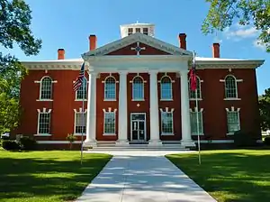 The Webster County courthouse was built in 1915 in the Neoclassical revival style. It was added to the National Register of Historic Places on September 18, 1980.
.JPG.webp) The Webster County Jails were added to the National Register of Historic Places on March 3, 2000.
The Webster County Jails were added to the National Register of Historic Places on March 3, 2000..JPG.webp) Post Office in Preston (ZIP code: 31824)
Post Office in Preston (ZIP code: 31824) Webster County Board of Education
References
- "U.S. Census website". United States Census Bureau. Retrieved 2008-01-31.
- "US Board on Geographic Names". United States Geological Survey. 2007-10-25. Retrieved 2008-01-31.
- "Find a County". National Association of Counties. Retrieved 2011-06-07.
- Hellmann, Paul T. (May 13, 2013). Historical Gazetteer of the United States. Routledge. p. 242. ISBN 978-1135948597. Retrieved 30 November 2013.
- "US Gazetteer files: 2010, 2000, and 1990". United States Census Bureau. 2011-02-12. Retrieved 2011-04-23.
- "Census of Population and Housing". Census.gov. Retrieved June 4, 2015.
- Georgia Board of Education, Retrieved June 30, 2010.
- School Stats, Retrieved June 30, 2010.
External links
- Consolidated Government of Webster County Including the city of Preston, Weston, and Webster County
- Webster County Board of Education including the city of Preston and Weston
- Webster County Sheriff's Department is the primary law enforcement agency for the entire county, and is an integral part of the County's system of justice.
Municipalities and communities of Webster County, Georgia, United States | ||
|---|---|---|
| Unincorporated communities | 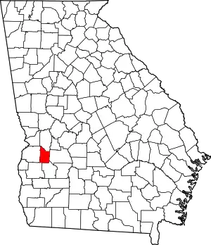 Map of Georgia highlighting Webster County | |
| ||