Puerto Bolivar, Colombia
Puerto Bolivar is a maritime port in the municipality of Uribia in the Guajira department of Colombia. It is the largest Colombian port. The port is located in the south head of Bahia Portete, an area of permanent winds and low rainfall, 75 km (47 mi) north of the city of Uribia and 166 km (103 mi) of Riohacha.
Puerto Bolivar | |
|---|---|
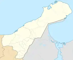 Puerto Bolivar Location in La Guajira and Colombia  Puerto Bolivar Puerto Bolivar (Colombia) | |
| Coordinates: 12°15′20″N 71°58′0.01″W | |
| Country | |
| Department | La Guajira Department |
| Municipality | Uribia Municipality |
| Time zone | UTC-5 (Colombia Standard Time) |
History
The Port of Puerto Bolivar, was created by decree No. 995 of April 5, 1982 by the President of Colombia, Julio César Turbay Ayala, with the name of Harbormaster of Bahia Portete in order to consolidate the presence of the state in this region of Colombia and exercise sovereignty through maritime legislation on domestic and foreign motor ships that arrived and sailed from Puerto Bolivar and quays of Portete and Puerto Nuevo. In 1986 during the administration of President Belisario Betancur its name was changed to Harbormaster of Puerto Bolivar.
Infrastructure
Railway
- The tracks are 150 km (93 mi) in length, connecting the Puerto Bolívar with Cerrejon mine
- The mine of the Cerrejón uses the only 1,435 mm (4 ft 8 1⁄2 in) standard gauge freight railway in the country
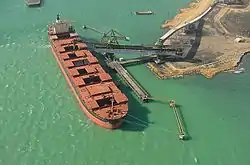
Puerto Bolívar
- Largest coal-export port in Latin America
- Covered conveyor belts and a direct-loading system since 1985
- Receives vessels of up to 180,000 tonnes (180,000 long tons; 200,000 short tons)
Airports
- 3,500 m (11,500 ft) of runway; Mine: 1,700 metres (5,600 ft) Puerto Bolívar: 1,600 metres (5,200 ft)
- Restricted flight area
Puerto Bolívar Motorway
- A motorway 150 km (93 mi) long for operational support and access for the population of La Guajira since 1982. It links the southern part of the department with the northern part.
Mushaisa Residential Unit
- Complete infrastructure for housing, commercial shops, and services for 2,200 residents
- 297 houses, 430 apartments, and a hotel for over 200 people
- Albania School: a bilingual school with a very high ICFES ranking. It is currently ranked 23 out of 12,273 educational institutions in the country
Climate
Puerto Bolivar has a hot desert climate (BWh) with little to no rainfall in all months except September, October and November.
| Climate data for Puerto Bolivar | |||||||||||||
|---|---|---|---|---|---|---|---|---|---|---|---|---|---|
| Month | Jan | Feb | Mar | Apr | May | Jun | Jul | Aug | Sep | Oct | Nov | Dec | Year |
| Average high °C (°F) | 31.4 (88.5) |
31.6 (88.9) |
32.2 (90.0) |
32.9 (91.2) |
33.6 (92.5) |
34.3 (93.7) |
34.3 (93.7) |
34.5 (94.1) |
33.8 (92.8) |
32.9 (91.2) |
32.1 (89.8) |
31.5 (88.7) |
32.9 (91.3) |
| Daily mean °C (°F) | 27.0 (80.6) |
27.0 (80.6) |
27.4 (81.3) |
28.1 (82.6) |
29.0 (84.2) |
29.5 (85.1) |
29.3 (84.7) |
29.5 (85.1) |
29.3 (84.7) |
28.8 (83.8) |
28.3 (82.9) |
27.5 (81.5) |
28.4 (83.1) |
| Average low °C (°F) | 24.6 (76.3) |
24.5 (76.1) |
24.9 (76.8) |
25.6 (78.1) |
26.3 (79.3) |
26.8 (80.2) |
26.6 (79.9) |
26.9 (80.4) |
26.9 (80.4) |
26.1 (79.0) |
26.0 (78.8) |
25.2 (77.4) |
25.9 (78.6) |
| Average rainfall mm (inches) | 4.8 (0.19) |
1.5 (0.06) |
2.6 (0.10) |
6.9 (0.27) |
27.3 (1.07) |
8.2 (0.32) |
11.0 (0.43) |
29.3 (1.15) |
60.2 (2.37) |
95.2 (3.75) |
53.5 (2.11) |
30.3 (1.19) |
330.8 (13.01) |
| Average rainy days | 2 | 1 | 1 | 2 | 3 | 2 | 2 | 4 | 7 | 10 | 7 | 5 | 46 |
| Average relative humidity (%) | 75 | 73 | 73 | 74 | 75 | 72 | 71 | 73 | 75 | 78 | 77 | 76 | 74 |
| Mean monthly sunshine hours | 170.5 | 143.9 | 136.4 | 117.0 | 145.7 | 171.0 | 217.0 | 207.7 | 165.0 | 124.0 | 123.0 | 148.8 | 1,870 |
| Mean daily sunshine hours | 9.0 | 9.1 | 8.7 | 8.1 | 7.9 | 8.0 | 8.9 | 9.1 | 7.9 | 7.2 | 7.6 | 8.4 | 8.3 |
| Source: IDEAM[1] | |||||||||||||
See also
- Puerto Bolivar Airport
- Titanoboa, world's largest prehistoric snake found in Cerrejón mine.
External links
- Carbones del Cerrejón Limited, Cerrejón., website. Contains information on operations as well as the company's environmental and community projects.