Pulau Brani
Pulau Brani is an island located off the southern coast of Singapore, near Keppel Harbour. The island is situated between the main island of Singapore and the resort island of Sentosa, and is linked to the mainland via Brani Terminal Avenue. The area of Pulau Brani is 1.22 square kilometres (0.47 square miles).
Pulau Brani | |
|---|---|
| Name transcription(s) | |
| • Chinese | 布拉尼岛 |
| • Pinyin | Bùlānídǎo |
| • Malay | Pulau Brani |
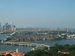 Pulau Brani lies to the right of the Keppel Harbour, as seen in this view from Sentosa's Tiger Sky Tower | |
.svg.png.webp) Pulau Brani Location of Pulau Brani within Singapore | |
| Coordinates: 1°15′36″N 103°50′00″E | |
| Country | Singapore |
The bulk of the island was occupied by the Malayan Command Ordnance Depot until 1937 when a new purpose built depot was constructed at Alexandra on the mainland.[1]
The British army had their maritime (water transport) base here, first with the RASC and then the RCT. Many families lived in the married quarters on the island. Primary children attended the British army school located near Buller Jetty, as did the children from army families on Blakang Mati (now Sentosa). Secondary age children had to go to the mainland by ferry, attending the Alexandra Schools at Gillman Barracks, then after 1964 either Bourne (in the Gillman buildings) or the brand new St John's Comprehensive in what is now the United World College in Dover Road.
Sources
- Victor R Savage, Brenda S A Yeoh (2003), Toponymics - A Study of Singapore Street Names, Eastern Universities Press, ISBN 981-210-205-1
External links
References
- Fernyhough, Alan Henry (1965). A History of the Royal Army Ordnance Corps, 1920-1945. Royal Army Ordnance Corps. p. 307.