Pyrenees Highway, Victoria
Pyrenees Highway in western Victoria, Australia is a 206 kilometre highway serving to link the Calder Highway in Elphinstone with the Glenelg Highway in Glenthompson. It intersects with the region's major freight route - the Western Highway in Ararat, in addition to the Midland Highway in Castlemaine and Sunraysia Highway in Avoca. The highway was formerly named the Elizabeth Highway prior to 1911.
Pyrenees Highway | |
|---|---|
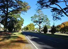 | |
Pyrenees Highway at Elmhurst | |
| General information | |
| Type | Highway |
| Length | 206 km (128 mi) |
| Route number(s) | |
| Former route number | |
| Major junctions | |
| East end | |
| West end | |
| Location(s) | |
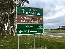
| Major settlements | Chewton, Castlemaine, Newstead, Moolort, Maryborough, Bung Bong, Avoca, Amphitheatre, Ararat, Willaura |
| Highway system | |
In 1855, Victoria enacted the Chinese Immigration Act 1855, severely limiting the number of Chinese passengers permitted on an arriving vessel. To evade the new law, many Chinese were landed in the south-east of South Australia and travelled more than 400 km across country to the Victorian goldfields, along tracks, including what is now the Pyrenees Highway.[1][2]
See also
![]() Australian Roads portal
Australian Roads portal
- Avoca, Victoria
- Australian gold rushes
- Highways in Australia
- Highways in Victoria
References
- "Chinese Immigration Act 1855 (Vic)". Documenting a Democracy. Museum of Australian Democracy. Retrieved 6 November 2013.
- "The Chinese Trek to Gold" (PDF). Australian Heritage. Archived from the original (PDF) on 23 March 2015. Retrieved 6 November 2013.
External links
![]() Media related to Pyrenees Highway at Wikimedia Commons
Media related to Pyrenees Highway at Wikimedia Commons