Qasr al-Hallabat
Qasr al-Hallabat (Arabic: قصر الحلابات) is a town in the Zarqa Governorate of north-western Jordan, north-east of the capital of Amman.[1] The town is named after the Umayyad desert castle located there. To the east of the castle stands the associated bath house of Hammam as-Sarah.
Qasr al-Hallabat
قصر الحلابات | |
|---|---|
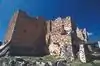
 Rebuilt mosque (left) and qasr (right) | |
 Qasr al-Hallabat Location in Jordan | |
| Coordinates: 32°5′00″N 36°21′47″E | |
| Country | |
| Governorate | Zarqa Governorate |
| Time zone | UTC + 2 |
Castle complex
.jpg.webp)
The complex of Qasr al-Hallabat is located in Jordan's eastern desert. Originally a Roman fortress constructed under Emperor Caracalla to protect its inhabitants from Bedouin tribes, this site dates to the second and third century AD, although there is trace evidence of Nabatean presence at the site. It was one fort of many on the Roman highway, Via Nova Traiana, a route that connected Damascus to Aila (modern-day Aqaba) by way of Petra and Philadelphia (modern-day Amman). However, by the eighth century, the Umayyad caliph Hisham ibn Abd al-Malik ordered the Roman structures to be demolished in order to redevelop this military site and its neighboring territory to become one of the grandest of all Umayyad desert complexes.
Guided by the extant plan, he incorporated a mosque (situated 15 meters southeast of the main structure), a complicated water system including five cisterns and a considerably large water reservoir, and a bathhouse. Furthermore, situated to the west of the palace remains an enclosed structure probably used for agricultural purposes such as cultivating olive trees and/or grapevines, of which only a one-layered stone footprint is still standing.
Of the mosque, three wall sections, including the mihrab in the southern wall, remain intact from the original structure. Recent reconstruction works have added back the collapsed elements.
The main palace is constructed of dark and light stones, basalt and limestone, and has a square floor plan with towers at each corner. Grand in stature, the principal structures were further enhanced with decorative mosaics depicting an assortment of animals, detailed frescoes and highly crafted stucco carvings. The site remains to be completely restored.
Approximately 1400 meters east of the palace stand the remains of the mosque at Qusayr al-Hallabat. Small in scale, it measures 10.70 by 11.80 meters and is constructed of layered limestone. Inside, two arching riwaqs divide the mosque into three sections. A rounded molding extends the perimeter of the space at the height of 2.10 meters. Similar to Qusayr 'Amra and Hammam as-Sarah, three tunnel vaults support the roof of the structure. Encircling the mosque from the north, west, and east stood a 3.30-meter wide portico.
Gallery
 Mosque (front view) after being largely rebuilt
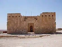
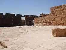 Entrance courtyard
 Mosaic floor at the castle
 Greek inscription on basalt block in secondary use
Modern town
The nearby modern town of Qasr Al-Hallabat is a municipality consisting of four villages. The area is inhabited by the Bani Sakhr tribe, especially the Al-Othman family.
External links
| Wikimedia Commons has media related to Qasr Al-Hallabat. |
References
- Maplandia world gazetteer
| Jordan | 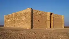 | |
|---|---|---|
| Syria |
| |
| Israel and Palestine | ||
Capital: Amman | |||||||||||
| |||||||||||
| |||||||||||
| |||||||||||
| |||||||||||
| |||||||||||
| |||||||||||
| |||||||||||
| |||||||||||
| |||||||||||
 | ||
Also See: Castles in Jordan | ||