Quarteira River
River Quarteira (Portuguese pronunciation: [kwɐɾˈtɐjɾɐ]) is a small river in the Portuguese region of the Algarve.[1] The river begins at the conflux of two tributary rivers a little north of the village of Paderne. The tributary rivers are the River de Alte and the River de Algibre.[2]
| Quarteira River | |
|---|---|
.JPG.webp) Quarteira River near the Acudes do Castelo, Paderne | |
 Mouth of the Quarteira River at Quarteira | |
| Location | |
| Country | Portugal |
| Region | Algarve |
| District | Faro |
| Municipality | Albufeira |
| Physical characteristics | |
| Source | Algibre River |
| • location | Paderne, Algarve |
| • coordinates | 37°10′51.9″N 8°12′27.8″W |
| • elevation | 50 m (160 ft) |
| 2nd source | Alte River |
| • location | Paderne |
| • coordinates | 37°10′51.9″N 8°12′27.8″W |
| • elevation | 50 m (160 ft) |
| Mouth | Into the Atlantic at Quarteira |
• coordinates | 37.074355°N 8.125467°W |
Description
The Quarteira is one of a number of small rivers in the central Algarve which make up the water ecosystem known as the Querença – Silves Aquifer System.[3]
Places of interest
A short distance from the confluence of the Quarteira the river passes the village of Paderne and then snakes in a large loop around a hill which is topped by the remains of the Moorish Castle of Paderne.[4] Below the castle are the remnants of two watermills. The first is to the Acudes do Castelo[5] which is in the north-west valley below the castle and the second watermill is called Alfarrobeiro and is south of the castle. Next to this watermill stands a Bridge built by the Romans. The Roman bridge is location on the rocky peninsular bend and was of strategic importance to the Romans, as it controlled the ancient Roman road Via Lusitanorum.
Gallery
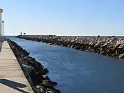 The outfall of Quarteira river into the Atlantic ocean at the entrance to Vilamoura marina which is in the municipality of Loulé, Algarve, Portugal.
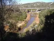
.jpg.webp) The Roman Bridge near Paderne Castle
The Roman Bridge near Paderne Castle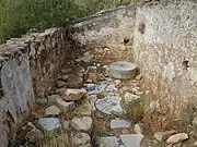 Alfarrobeira Watermill
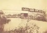 Old photograph of the railway bridge across the river near Boliqueime
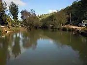 Quarteira River near the Acudes do Castelo, Paderne
References
- Portuguese civilian survey: Sheet 52B Albufeira. Publishers: Instituto Geográfico Português (Portugal Civilian Survey. Scale:1:50,000. ISBN 972-8867-11-5
- The Algarve. Sheet Map showing the course of the River Quarteira and its Confluences. Rough guides – Penguin Group. 2010. ISBN 9781848364981.
- "Quantifying and modelling the contribution of streams that recharge the Querença – Silves Aquifer in south Portugal" (PDF). Information about the Aquifer System. Natural Hazards and Earth System Sciences.
- Nobre, Idalina Nunes (2009). Albufeira - from the Middle Ages to the Old Regime. Reference to location of the castle on a sharp meanderbof the river Quarteira. Albufeira City Council. p. 28. ISBN 978-972-8124-36-6.
- Gordalina, Rosário (2008), SIPA (ed.), Azenha em Paderne/Moinho de Água em Paderne (PT050801030027) (in Portuguese), Lisbon, Portugal: SIPA – Sistema de Informação para o Património Arquitectónico, retrieved 27 February 2012
- "Spain & Portugal 2012, Tourist and Motoring Atlas. Pub:Michelin, 2011, ISBN 978-2-06-717415-3
Rivers and Streams of the Algarve | ||
|---|---|---|
 | ||