Quebec Route 360
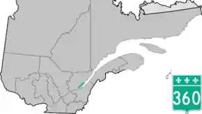
Route 360 is a provincial highway located in the Capitale-Nationale region in the south central part of the province of Quebec. The highway runs from Quebec City's Beauport sector and ends at the junction of Route 138 northeast of Saint-Tite-des-Caps in the Charlevoix region. For a large portion of its length it runs right beside Route 138, overlapping it briefly near Beaupré. The road also travels through significant portions of the Charlevoix touristic area and also crosses Mont-Sainte-Anne ski resort and the Montmorency Falls located at the Montmorency River which connects the Saint Lawrence River nearby.
| ||||
|---|---|---|---|---|
 | ||||
| Route information | ||||
| Maintained by Transports Québec | ||||
| Length | 1.0 km[1] (0.6 mi) | |||
| Major junctions | ||||
| West end | ||||
| East end | ||||
| Location | ||||
| Major cities | Quebec City | |||
| Highway system | ||||
| ||||

Towns along Route 360
- Quebec City (including the Beauport sector)
- Boischatel
- L'Ange-Gardien
- Château-Richer
- Sainte-Anne-de-Beaupré
- Beaupré
- Saint-Férréol-des-Neiges
- Saint-Tite-des-Caps
See also
References
- Ministère des transports, "Distances routières", page (?), Les Publications du Québec, 2005
This article is issued from Wikipedia. The text is licensed under Creative Commons - Attribution - Sharealike. Additional terms may apply for the media files.