Quiscapampa
Quiscapampa or Quiscapanca (possibly from Quechua kiska thorn, p'anqa bract,[2] "thorn bract")[1][3][4] is a mountain in the Chila mountain in the Andes of Peru, about 5,400 m (17,717 ft) high. It is located in the Arequipa Region, Castilla Province, Choco District. Quiscapampa lies northwest of Ojeccasa and southwest of Airicoto.[1]
| Quiscapampa | |
|---|---|
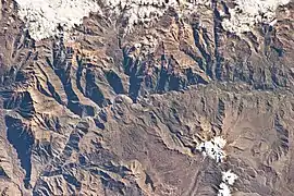 The Colca River and Quiscapampa north of it (upper left) as seen from the ISS | |
| Highest point | |
| Elevation | 5,400 m (17,700 ft) [1] |
| Coordinates | 15°27′48″S 72°06′29″W |
| Geography | |
 Quiscapampa Peru | |
| Location | Peru, Arequipa Region, Castilla Province |
| Parent range | Andes, Chila |
Jesjapanca is also the name of the peak southeast of the mountain at 15°29′59″S 72°03′53″W. It is about 5,000 m (16,404 ft) high.[1]
References
- escale.minedu.gob.pe - UGEL map of the Caylloma Province 1 (Arequipa Region) showing Quiscapampa
- Teofilo Laime Ajacopa, Diccionario Bilingüe Iskay simipi yuyayk'ancha, La Paz, 2007 (Quechua-Spanish dictionary)
- "South America Maps". Joint Operations Graphic. Retrieved May 28, 2015. showing Quiscapanca
- Resumen - Ministerio de Energía y Minas, CEDEMIN S.A.C., Actualización del Plan de Cierre de Minas de la UEA Chaquelle, see Quiscapanca
This article is issued from Wikipedia. The text is licensed under Creative Commons - Attribution - Sharealike. Additional terms may apply for the media files.