R566 road (Ireland)
The R566 road is a regional road in Ireland. It is a road on the Iveragh Peninsula in County Kerry.[1][2] Part of the road is on the Wild Atlantic Way.[3]
| ||||
|---|---|---|---|---|
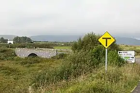 R566 bridge at Emlaghmore | ||||
| Route information | ||||
| Length | 25.5 km[1][2] (15.8 mi) | |||
| Major junctions | ||||
| From | ||||
| ||||
| To | ||||
| Road network | ||||
| ||||

The R566 travels southwest from the N70 (Ring of Kerry) to Ballinskelligs. At Ballinskelligs, the road becomes the Skellig Ring, travelling northwest via the coast. Along this coast, high-cliffed Puffin Island, an important seabird reserve,[4] lies just offshore. The road terminates at the R565 at Portmagee, where Valentia Island may be reached by bridge. The R566 is 25.5 km (15.8 mi) long.[1]
References
- Google (16 May 2016). "Ring of Kerry to R565" (Map). Google Maps. Google. Retrieved 16 May 2016.
- "S.I. No. 54/2012 – Roads Act 1993 (Classification of Regional Roads) Order 2012". Government of Ireland. 28 Feb 2012. Retrieved 16 May 2016.
- "Wild Atlantic Way: Explore The Route". Fáilte Ireland. Retrieved 16 May 2016.
- "Puffin Island". BirdWatch Ireland. Retrieved 4 Jun 2016.
This article is issued from Wikipedia. The text is licensed under Creative Commons - Attribution - Sharealike. Additional terms may apply for the media files.
