RAF Elgin
Royal Air Force Elgin or more simply RAF Elgin is a former Royal Air Force satellite airfield located 3 miles (4.8 km) south west of Elgin, Moray, Scotland, to the east of the B9010, in the area bounded by Pittendreich in the North, Wester Manbeen in the west, Easter Manbeen to the south and the River Lossie to the east.
| RAF Elgin | |||||||||||
|---|---|---|---|---|---|---|---|---|---|---|---|
| Near Elgin, Moray in Scotland | |||||||||||
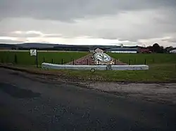 The site of RAF Elgin during 2006, including the No. 20 Operational Training unit memorial | |||||||||||
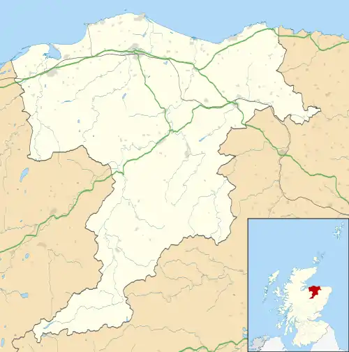 RAF Elgin Location in Moray | |||||||||||
| Coordinates | 57°37′31.5″N 3°20′57.1″W | ||||||||||
| Type | Satellite airfield | ||||||||||
| Site information | |||||||||||
| Owner | Air Ministry | ||||||||||
| Operator | Royal Air Force | ||||||||||
| Controlled by | RAF Fighter Command | ||||||||||
| Condition | Closed | ||||||||||
| Site history | |||||||||||
| Built | 1940 | ||||||||||
| Built by | Royal Engineers | ||||||||||
| In use | 1940–1947 | ||||||||||
| Fate | Returned to agricultural use | ||||||||||
| Airfield information | |||||||||||
| |||||||||||
History
Establishment
RAF Elgin was built as a satellite landing ground (SLG) for RAF Lossiemouth which was approximately 8.85 kilometres (5.50 mi) to the north. Construction work was undertaken by the Royal Engineers and the site opened in early June 1940.[1]
The airfield was located on agricultural land between the River Lossie to the east and the B9010 Elgin to Forres road to the west, approximately 1.5 kilometres (0.93 mi) south east of Elgin. The site extended to 180.5 hectares (446 acres) with a further 6.50 hectares (16.1 acres) for domestic accommodation and administrative buildings located to the west, between Wester Manbeen Cottages and Miltonduff.[2][1] The airfield had three grass runways: north/south which was 1,280 metres (4,200 ft), east/west which was 1,143 meters (3,750 ft) and south east/north west which was 1,005 meters (3,297 ft). Two hangars were located at the south west side of the airfield, a B1 and a T2 type, and a bomb store was located to the south of the north/south runway.[3] Twenty concrete hard-standings were created around the north and western boundaries for the parking of aircraft.[2] RAF Elgin was unusual in that it had its own water works, consisting of dam across a stream and an underground pumping station.[3]
Operations
Due to the threat of invasion by Nazi Germany, the airfield when completed was obstructed by the Royal Engineers to prevent enemy landings.[1] The first flying unit arrived on 13 August 1940, when No. 57 Squadron relocated from RAF Lossiemouth to create space for the expansion of No. 20 Operational Training Unit (No. 20 OTU). The squadron operated the Bristol Blenheim light bomber in the anti-shipping role, moving to RAF Wyton in November 1940. During this period, the airfield was also used by Lossiemouth based Blenheims belonging to No. 21 Squadron as well as Westland Lysanders of No. 614 Squadron operating from RAF Longman which were used for coastal patrols.[4]
On 26 October 1940, RAF Lossiemouth was attacked by three Heinkel He 111 of the Luftwaffe.[5] To protect the area from further attacks,Hawker Hurricanes of No. 232 Squadron were deployed to RAF Elgin from RAF Skitten. The Hurricanes carried out air defence duties without engagement with the enemy, until April 1941 when they moved to RAF Montrose. They were replaced by detachments of Hurricanes of No. 17 Squadron from RAF Sumburgh and RAF Castleton.[4]
A-Flight of No. 20 OTU, equipped with the Vickers Wellington medium-bomber, began using RAF Elgin for training on 18 April 1941. Flying continued throughout 1941 and 1942, with the airfield predominately used by the unit's Wellingtons and Avro Ansons multi-role aircraft and occasionally by Armstrong Whitworth Whitleys medium-bombers belonging to No. 19 OTU based at nearby RAF Kinloss. Wellingtons of No. 20 OTU were also involved in strategic bombing raids on German cities throughout 1942, the training aircraft being required to help reach the target number of 1000 bombers per raid.[4][6]
The airfield was used to store surplus aircraft from 1945 and was closed in 1947.
Units
- No. 17 Squadron RAF[7]
- No. 57 Squadron RAF[8]
- No. 232 Squadron RAF[9]
- No. 614 Squadron RAF[10]
- No. 19 (Pilots) Advanced Flying Unit RAF[10]
- No. 20 Operational Training Unit RAF (OTU)[10]
- No. 44 Maintenance Unit RAF[10]
- No. 45 Maintenance Unit RAF[10]
- No. 46 Maintenance Unit RAF[10]
References
Citations
- Hughes 1999, p. 75.
- "Elgin Airfield". Canmore. Historic Environment Scotland. Retrieved 30 January 2021.
- Hughes 1999, pp. 75, 78.
- Hughes 1999, p. 76.
- Hughes 1999, p. 110.
- Hughes 1999, p. 112.
- Jefford 2001, p. 30.
- Jefford 2001, p. 43.
- Jefford 2001, p. 74.
- "Elgin II (Bogs of Mayne)". Airfields of Britain Conservation Trust. Retrieved 28 February 2013.
Bibliography
- Hughes, Jim (1999). A Steep Turn to the Stars. Peterborough, GMS Enterprises. ISBN 978-1-870384-71-1
- Jefford, C.G. RAF Squadrons, a Comprehensive Record of the Movement and Equipment of all RAF Squadrons and their Antecedents since 1912. Shrewsbury, Shropshire, UK: Airlife Publishing, 2001. ISBN 1-84037-141-2.
| Formations and units |
|  | ||||||
|---|---|---|---|---|---|---|---|---|
| Branches and components | ||||||||
| Reserve forces | ||||||||
| Associated civil organisations | ||||||||
| Equipment | ||||||||
| Personnel |
| |||||||
| Appointments | ||||||||
| Symbols and uniform | ||||||||