Radnor Forest
Radnor Forest (Welsh: Fforest Clud) in the county of Radnorshire, Wales is a rock dome composed of Silurian shales, mudstones and limestone in Mid Wales, and a forest only in the medieval sense of an unenclosed area used for hunting.[1] It lies within the Welsh Marches region since Offa's Dyke lies nearby to the east.

.jpg.webp)
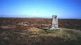
The area lies to the north of the Black Mountains and to the east of the Cambrian Mountains. Hergest Ridge is immediately to the south-east of the area (just across the English border into Herefordshire), near the small town of Kington. The highest point in the area is Rhos Fawr or Great Rhos, a broad featureless plateau which reaches 660 metres (2,165 ft), and is equipped with a trig point to mark the summit. A similar plateau adjoining to the east, Black Mixen is the only Nuttall to have a communications mast (a radio transmitter) on its summit.[2]
There is a famous waterfall or cascade on the eastern side of the mountain, called Water Break-its-neck. It can be reached via a short rough track or forestry road from the A44 main road from Kington to Aberystwyth, shortly after New Radnor, and there is a small car park for visitors to the Warren Wood reserve maintained by Natural Resources Wales. The cascade can be reached after a short walk along a well built walkway beside the river in the hanging valley. There are two other small car parks around the edge of the forest to the north and the east which allow public access to the moorland and woods. There is also a large Natural Resources Wales plantation on the northern slopes of the massif.
Geology
The massif is formed from argillaceous rocks of Ludlow age, i.e. late Silurian around 425 million years ago.[3] The strata are exposed around Harley Dingle and Whinyard Rocks. In 2020 the area was in course of being geologically mapped for the publication of the 'Knighton' 1:50,000 scale geological map by the British Geological Survey, no such work having been undertaken in this area since the middle of the nineteenth century.[4][5]
Site of Special Scientific interest


Part of the area is a designated and protected SSSI, with rare saxifrage and other plants. It covers the highest peaks and a rocky gorge near the centre.
The vegetation of the summit ridges is fairly uniform, and is dominated by a mixture of dwarf shrubs, heather, crowberry, and bilberry. Mixed with these dwarf shrubs are hare's-tail cottongrass, purple moor-grass, sedges such as Carex binervis and a number of mosses and lichens. The dwarf shrubs are very well grown and suggest the area has suffered little from fires in the recent past and that grazing pressures are light. Purple moor-grass is but thinly scattered and does not form the extensive stands so familiar only a few miles west. Peat pools support common cottongrass Eriophorum angustifolium.
The steep-sided dingles and rock outcrops of the Forest's edge support rich plant communities, since these eastern Silurian shales are slightly calcareous. Mossy saxifrage and rock stonecrop are common on some cliff faces, with marjoram and a number of interesting mosses and liverworts.
A variety of typical upland breeding birds are present, including raptors such as the red kite and common buzzard, as well as red grouse, whinchat, stonechat, wheatear and the dipper at or near the many streams in the forest. Radnorshire Wildlife Trust maintain the 33 hectare Mynydd Ffoesidoes Nature Reserve on the summit plateau.[6]
Archaeology
The topmost parts of the forest exhibit several Bronze Age round barrows, and there are also several ring cairns in the area. Most occur on or near the peaks, such as Black Mixen and Bache Hill. Prehistoric settlement is shown by hut circles often present as distinctive platforms. The forest was exploited as a military training area in the last war, and has remnants of such activity such as bomb craters and slit trenches. Part of the site is still used for testing ammunition and ordnance; there are warning flags and signs at the boundaries of the Harley valley range. It includes a distinctive landscape feature known as "The Three Wriggles", a set of three gulleys running down the mountain slope on the western side of the Harley valley. There is also some evidence for mining activity.
The town of New Radnor was a planned Norman settlement, and there is a large mound just to the north of the town marking the site of a motte and bailey castle.
Legends
According to a legend, the local people built four churches in a circle around the Radnor Forest in order to contain the last dragon in Wales, who lay sleeping in the area. The churches, at Llanfihangel Cefnllys, Llanfihangel Rhydithon (Dolau), Llanfihangel Nant Melan and Llanfihangel Cascob, were all dedicated to St Michael (Welsh: Mihangel) victor over the dragon. Some people believed that the dragon would awaken if any of the four churches were destroyed.[7]
Nearby towns
There are several small market towns at the feet of the hills, including the county town of Powys, Llandrindod Wells, Kington, Herefordshire, Knighton, Powys and Presteigne. The latter town is in Powys and was formerly the county town of Radnorshire. The village of New Radnor sits at the southern base of the hills, and there are several other villages nearby, such as Old Radnor, Gladestry and Cascob.
References
- "Radnor Forest, Mid Wales". Retrieved 2007-04-22.
- "Pumlumon". Archived from the original on 2002-05-08. Retrieved 2007-04-22.
- "Geoindex Onshore". British Geological Survey. Retrieved 19 June 2020.
- "sheet 56 Radnor". Maps Portal. British Geological Survey. Retrieved 19 June 2020.
- "The future for geology in the Marches: a BGS perspective" (PDF). Shropshire Geology. Shropshire Geological Society. Retrieved 19 June 2020.
- "Mynydd Ffoesidoes Nature Reserve". Radnorshire Wildlife Trust. Retrieved 19 June 2020.
- "St Michael and the Dragon of Radnor Forest". Church in Wales, Diocese of Swansea and Brecon.
