Raduil Point
Raduil Point (Bulgarian: нос Радуил, ‘Nos Raduil’ \'nos ra-du-'il\) is a point forming the northwest extremity of Astrolabe Island in Bransfield Strait off Trinity Peninsula, Antarctica.
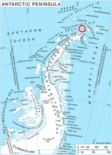
Location of Astrolabe Island in the Antarctic Peninsula region.
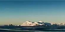
Astrolabe Island from northwest, with Raduil Point in the foreground.
The point is named after the settlement of Raduil in southwestern Bulgaria.
Location
Raduil Point is located at 63°18′14″S 58°44′55″W, which is 4.5 km (2.8 mi) northwest of Sherrell Point and 3.15 km (1.96 mi) west of Drumohar Peak. German-British mapping in 1996.
Maps
- Trinity Peninsula. Scale 1:250000 topographic map No. 5697. Institut für Angewandte Geodäsie and British Antarctic Survey, 1996.
- Antarctic Digital Database (ADD). Scale 1:250000 topographic map of Antarctica. Scientific Committee on Antarctic Research (SCAR). Since 1993, regularly upgraded and updated.
References
- Raduil Point. SCAR Composite Gazetteer of Antarctica
- Bulgarian Antarctic Gazetteer. Antarctic Place-names Commission. (details in Bulgarian, basic data in English)
External links
- Raduil Point. Copernix satellite image
This article includes information from the Antarctic Place-names Commission of Bulgaria which is used with permission.
This article is issued from Wikipedia. The text is licensed under Creative Commons - Attribution - Sharealike. Additional terms may apply for the media files.
