Ranch to Market Road 1623
Ranch to Market Road 1623 (RM 1623) is a 23.386-mile (37.636 km) farm to market road in Gillespie and Blanco counties, Texas.[1]
| ||||
|---|---|---|---|---|
| ||||
| Route information | ||||
| Maintained by TxDOT | ||||
| Length | 23.386 mi[1][lower-alpha 1] (37.636 km) | |||
| Existed | 1951–present | |||
| Major junctions | ||||
| North end | ||||
| East end | ||||
| Location | ||||
| Counties | Gillespie, Blanco | |||
| Highway system | ||||
| ||||

Route description
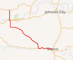
RM 1623 begins in eastern Gillespie County at an intersection with RM 2721.[2] It travels to the south into Stonewall, where it crosses Ranch Road 1, and has a one-block eastward concurrency with US 290 before continuing southward. It then turns to the southeast and crosses into Blanco County.[3] The route intersects RM 1888 before turning to the east and running along the north bank of the Blanco River into Blanco.[4] The RM 1623 designation ends at US 281 in central Blanco; the roadway continues as Loop 163.[1]
History
FM 1623 was first designated in Blanco County in 1951, and ran from US 281 in Blanco to the west approximately 5.0 mi (8.0 km). Its length was extended to 10.3 mi in 1953 and increased again in 1954; the designation ended at the Gillespie County line. The extension into Gillespie County and to US 290 would be approved in 1955. The route was redesignated in 1969 as an RM route, the same year the extension to RM 2721 was added.[1]
Major intersections
| County | Location | mi[5][lower-alpha 1] | km | Destinations | Notes |
|---|---|---|---|---|---|
| Gillespie | | 0.0 | 0.0 | Northern terminus[lower-alpha 2] | |
| Stonewall | 3.0 | 4.8 | |||
| 3.4 | 5.5 | Northern end of US 290 concurrency | |||
| 3.6 | 5.8 | Eastern end of US 290 concurrency | |||
| Blanco | | 18.4 | 29.6 | ||
| Blanco | 23.6 | 38.0 | 4th Street east (Loop 163 south) | Eastern terminus; roadway continues as 4th Street | |
1.000 mi = 1.609 km; 1.000 km = 0.621 mi
| |||||
Notes
- The certified length given is shorter than the actual mileage, as the TxDOT description of RM 1623 considers it to be discontinuous at US 290.
- The section between RM 2721 and US 290 in Stonewall is signed north–south, but the majority of the route is signed west–east.
References
- Transportation Planning and Programming Division (n.d.). "Ranch to Market Road No. 1623". Highway Designation Files. Texas Department of Transportation. Retrieved January 13, 2011.
- Transportation Planning and Programming Division (2012). Texas County Mapbook (PDF) (Map) (2012 ed.). 1:120,000. Texas Department of Transportation. p. 371. OCLC 867856197. Retrieved January 13, 2011.
- Transportation Planning and Programming Division (2012). Texas County Mapbook (PDF) (Map) (2012 ed.). 1:120,000. Texas Department of Transportation. p. 401. OCLC 867856197. Retrieved January 13, 2011.
- Transportation Planning and Programming Division (2012). Texas County Mapbook (PDF) (Map) (2012 ed.). 1:120,000. Texas Department of Transportation. p. 402. OCLC 867856197. Retrieved January 13, 2011.
- Google (January 13, 2011). "Overview Map of Ranch to Market Road 1623 Distances Between Intersections" (Map). Google Maps. Google. Retrieved January 13, 2011.