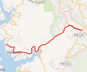
Ranch to Market Road 2769
Ranch to Market Road 2769 (RM 2769) is a 7.151-mile (11.508 km) state-maintained Ranch to Market Road located in Travis County, Texas. A portion of RM 2769 carries the name Anderson Mill Road.
| ||||
|---|---|---|---|---|

| ||||
| Route information | ||||
| Length | 7.151 mi[1] (11.508 km) | |||
| Existed | 1962–present | |||
| Major junctions | ||||
| West end | Lime Creek Road in Volente | |||
| East end | ||||
| Location | ||||
| Counties | Travis | |||
| Highway system | ||||
| ||||
Route description
RM 2769 begins in Volente at an intersection with Lime Creek Road. It proceeds northeast to an intersection with Anderson Mill Road, along which it continues for one mile (1.6 km) before terminating at RM 620 near the Travis–Williamson county line.[2]
History
RM 2769 was designated on May 2, 1962, with its current description.[1]
RM 2769 originally ran continuously from Volente to its intersection with RM 620. In 2007, Anderson Mill Road was extended along the most easterly mile (1.6 km) of this right-of-way. RM 2769 now approaches from the southwest and continues onto Anderson Mill Road using a T-intersection.
Major intersections
| County | Location[3] | mi[1] | km | Destinations | Notes |
|---|---|---|---|---|---|
| Travis | Volente | 0.000 | 0.000 | Lime Creek Road | Western terminus |
| Travis–Williamson county line | Austin–Cedar Park line | 7.151 | 11.508 | Eastern terminus; road continues as Anderson Mill Road | |
| 1.000 mi = 1.609 km; 1.000 km = 0.621 mi | |||||
References
- Transportation Planning and Programming Division (n.d.). "Ranch to Market Road No. 2769". Highway Designation Files. Texas Department of Transportation. Retrieved May 29, 2018.
- Google (July 23, 2015). "Overview Map of RM 2769" (Map). Google Maps. Google. Retrieved July 23, 2015.
- Transportation Planning and Programming Division (2014). Texas County Mapbook (PDF) (Map) (2014 ed.). 1:120,000. Texas Department of Transportation. p. 366. Retrieved May 29, 2018.
