Rayong
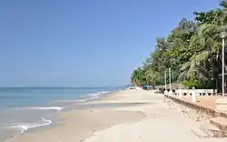
Rayong (Thai: ระยอง, pronounced [rā.jɔ̄ːŋ]) is a city (thesaban nakhon) on the east coast of the Gulf of Thailand and the capital of Rayong Province. It covers tambons Tha Pradu and Pak Nam and parts of tambons Choeng Noen and Noen Phra, all within Mueang Rayong District. As of 2016 the population was 64,256 (est.). The main industry is fishing, and it is also the main producer of Thailand's fish sauce. It is also the center of the chemical and auto industries. In 2012 Ford Motor Company opened an assembly plant in Rayong to expand Ford's presence in the ASEAN area, employing some 2,200 people.[1]
Rayong
ระยอง | |
|---|---|
| City of Rayong เทศบาลนครระยอง | |
 Chakphong, Klaeng District, Rayong | |
 Seal | |
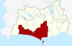 Location in Rayong Province | |
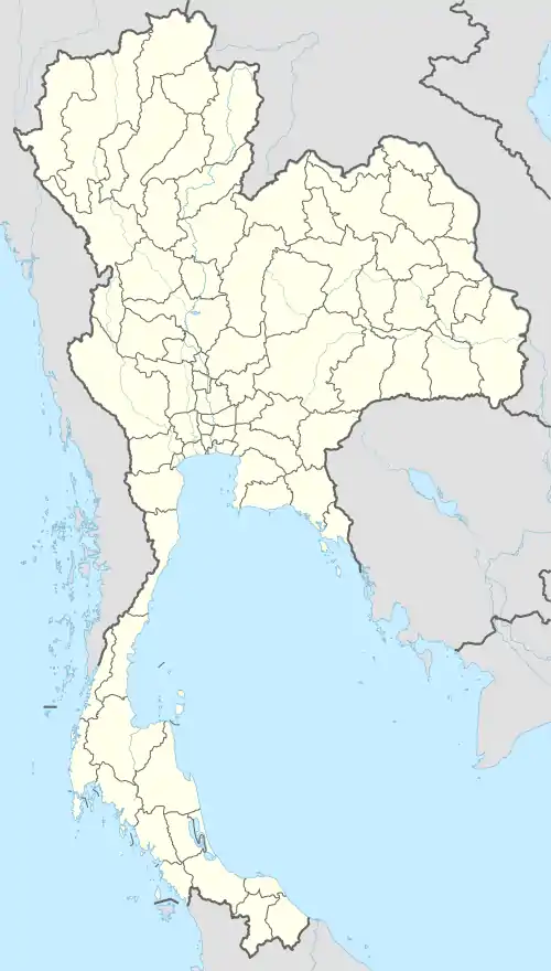 Rayong Location in Thailand | |
| Coordinates: 12°40′27″N 101°16′44″E | |
| Country | Thailand |
| Province | Rayong |
| District | Mueang Rayong |
| Government | |
| • Type | City Municipality |
| • Mayor | Worawit Sopchokchai |
| Area | |
| • Total | 16.95 km2 (6.54 sq mi) |
| Population (2016) | |
| • Total | 64,256 |
| • Density | 3,800/km2 (9,800/sq mi) |
| Time zone | UTC+7 (ICT) |
| Area code | (+66) 38 |
| Website | rayongcity |
Rayong was named an Asia-Pacific City of the Future by the Financial Times in 2017.[2]
History
During the late Ayutthaya period, when the former capital of Thailand was being destroyed by the invading Burmese, general Phaya Tak marched his troops to Rayong in order to build up his navy before proceeding on to Chanthaburi. He was later anointed "king" in Rayong. Phaya Tak later became King Taksin of the Kingdom of Thonburi, after which he returned to Ayutthaya, defeated the Burmese and set up a new capital in Thonburi.[3]
Yomjinda Road bisects one of Rayong's oldest settlements. The road follows the Rayong River which, in the reign of King Rama VI, was the chief means of transport. The community rehabilitated the old town and today it has become a tourist destination.[4]
People
- Sutthi Atchasai: (environmentalist fighting pollution at Map Ta Phut; died in 2014)[5]
Gallery
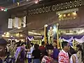 Rayong Storytelling Festival, Yomjinda Road, 31 March 2018
 Yomjinda Road, 31 March 2018
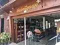 Rayong Museum, Yomjinda Road
Climate
| Climate data for Rayong (1981–2010) | |||||||||||||
|---|---|---|---|---|---|---|---|---|---|---|---|---|---|
| Month | Jan | Feb | Mar | Apr | May | Jun | Jul | Aug | Sep | Oct | Nov | Dec | Year |
| Record high °C (°F) | 37.0 (98.6) |
37.5 (99.5) |
37.9 (100.2) |
40.0 (104.0) |
39.5 (103.1) |
38.0 (100.4) |
38.0 (100.4) |
38.0 (100.4) |
37.3 (99.1) |
37.2 (99.0) |
37.3 (99.1) |
37.5 (99.5) |
40.0 (104.0) |
| Average high °C (°F) | 31.9 (89.4) |
32.5 (90.5) |
33.2 (91.8) |
34.3 (93.7) |
33.6 (92.5) |
32.7 (90.9) |
32.3 (90.1) |
32.0 (89.6) |
31.9 (89.4) |
32.3 (90.1) |
32.6 (90.7) |
32.0 (89.6) |
32.6 (90.7) |
| Daily mean °C (°F) | 26.2 (79.2) |
27.9 (82.2) |
29.0 (84.2) |
30.0 (86.0) |
29.8 (85.6) |
29.4 (84.9) |
29.0 (84.2) |
28.8 (83.8) |
28.2 (82.8) |
27.6 (81.7) |
27.2 (81.0) |
26.0 (78.8) |
28.3 (82.9) |
| Average low °C (°F) | 21.5 (70.7) |
24.5 (76.1) |
26.2 (79.2) |
27.1 (80.8) |
26.9 (80.4) |
26.8 (80.2) |
26.5 (79.7) |
26.4 (79.5) |
25.4 (77.7) |
24.5 (76.1) |
23.3 (73.9) |
21.3 (70.3) |
25.0 (77.0) |
| Record low °C (°F) | 14.5 (58.1) |
16.5 (61.7) |
17.5 (63.5) |
22.6 (72.7) |
22.3 (72.1) |
21.5 (70.7) |
22.0 (71.6) |
22.5 (72.5) |
21.7 (71.1) |
18.3 (64.9) |
17.0 (62.6) |
13.3 (55.9) |
13.3 (55.9) |
| Average rainfall mm (inches) | 20.7 (0.81) |
36.5 (1.44) |
70.3 (2.77) |
81.6 (3.21) |
198.6 (7.82) |
165.1 (6.50) |
171.8 (6.76) |
132.3 (5.21) |
255.2 (10.05) |
194.4 (7.65) |
50.8 (2.00) |
5.9 (0.23) |
1,383.2 (54.46) |
| Average rainy days | 2.1 | 4.1 | 5.1 | 7.4 | 15.0 | 14.3 | 14.3 | 14.4 | 18.1 | 16.7 | 5.9 | 1.3 | 118.7 |
| Average relative humidity (%) | 74 | 76 | 77 | 77 | 79 | 79 | 79 | 80 | 82 | 82 | 74 | 70 | 77 |
| Mean monthly sunshine hours | 229.4 | 211.9 | 201.5 | 204.0 | 155.0 | 114.0 | 117.8 | 114.7 | 108.0 | 145.7 | 189.0 | 226.3 | 2,017.3 |
| Mean daily sunshine hours | 7.4 | 7.5 | 6.5 | 6.8 | 5.0 | 3.8 | 3.8 | 3.7 | 3.6 | 4.7 | 6.3 | 7.3 | 5.5 |
| Source 1: Thai Meteorological Department[6] | |||||||||||||
| Source 2: Office of Water Management and Hydrology, Royal Irrigation Department (sun and humidity)[7] | |||||||||||||
References
- Priddle, Alisa (2 May 2012). "Ford opens assembly plant in Thailand". Detroit Free Press. Retrieved 5 May 2012.
- Newton, Tim (29 September 2017). "Punching above its weight – Rayong, Thailand". The Taiger. Retrieved 2 July 2019.
- "Rayong Province, Thailand tourism portal". www.tripsthailand.com. Retrieved 19 April 2016.
- "Yomjinda old town". Travelfish. Retrieved 12 July 2018.
- Atthakor, Ploenpote (17 July 2014). "Green activist movement loses warrior". Bangkok Post. Retrieved 12 July 2018.
- "Climatological Data for the Period 1981–2010". Thai Meteorological Department. p. 20–21. Retrieved 6 August 2016.
- "ปริมาณการใช้น้ำของพืชอ้างอิงโดยวิธีของ Penman Monteith (Reference Crop Evapotranspiration by Penman Monteith)" (PDF) (in Thai). Office of Water Management and Hydrology, Royal Irrigation Department. p. 98. Retrieved 6 August 2016.
External links
| Wikimedia Commons has media related to Rayong. |
 Rayong travel guide from Wikivoyage
- The old market on Yomjinda Road
- Rayong
- ถนนยมจินดา ยมจินดา ธรรมดาซะที่ไหน (Yomjinda Road is not normal)
- ย่านเมืองเก่าระยอง ถนนยมจินดา Rayong's old town
| Authority control |
|---|