Reedyville, Kentucky
Reedyville is an Unincorporated community in eastern Butler County, Kentucky, United States. The town is supposedly named for the nearby Big Reedy Creek, a tributary of the Green River.[2] Reedyville is part of the Bowling Green Metropolitan Statistical Area.
Reedyville | |
|---|---|
 Reedyville Location within the state of Kentucky  Reedyville Reedyville (the United States) | |
| Coordinates: 37°11′29″N 86°25′54″W | |
| Country | United States |
| State | Kentucky |
| County | Butler |
| Elevation | 522 ft (159 m) |
| Time zone | UTC-6 (Central (CST)) |
| • Summer (DST) | UTC-5 (CDT) |
| GNIS feature ID | 508917[1] |
Geography
The community is located along Kentucky Route 185 about 3.4 miles (5.5 km) south of Roundhill, or about 15 miles (24 km) north of Bowling Green.[3]
Education
Students in Reedyville attend Butler County Schools in Morgantown, Kentucky, including Butler County Middle and high schools. The closest elementary school is North Butler Elementary, located about halfway between Aberdeen and Jetson, Kentucky.
At one time prior to the 1960s, the Reedyville area's students attended the independently-run Dripping Spring School near the now-extinct community of Threikel, which has since been demolished.[4]
Points of interest
Since 1901, the U.S. Army Corps of Engineers once operated the Green River Lock and Dam Number 5, located three miles outside of Reedyville to the south. It, along with lock and dam numbers 4 and 6 were shut down due to the failure of all three dams.
Since 2012, the area is also home to the Big Reedy Christian Camp, a privately funded summer camp where school-age students from churches throughout the area can attend.
Post office
Reedyville's post office was in operation from 1860 to 1964.[5] The town is not currently served by a post office of its own; the village post office in nearby Roundhill is the default post office for Reedyville, thus using the zip code 42275.
Nearby cities
References
- U.S. Geological Survey Geographic Names Information System: Reedyville, Kentucky
- “Reedyville Populated Place Profile / Butler County, Kentucky Data”. kentucky.hometownlocator.com. Retrieved October 17, 2019.
- DeLorme (2010). Kentucky Atlas & Gazetteer (Map). 1:150000. Yarmouth, ME: DeLorme. p. 64. § E3. ISBN 0-89933-340-0.
- Kentucky Department of Highways (1958). Butler County Highway Map (PDF) (Map). 1:125000. Frankfort: Kentucky Department of Highways. Retrieved December 24, 2015.
- "Notification Service | Post Offices".
Municipalities and communities of Butler County, Kentucky, United States | ||
|---|---|---|
| Cities | 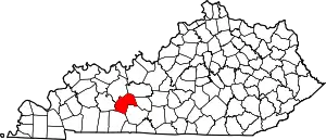 Location of Butler County, Kentucky | |
| Unincorporated communities | ||
| Footnotes | ‡This populated place also has portions in an adjacent county or counties | |
| ||