Rewa, Madhya Pradesh
Rewa is a city in north-eastern part of Madhya Pradesh state in India. It is the administrative centre of Rewa District and Rewa Division. The city lies about 420 kilometres (261 mi) northeast of the state capital Bhopal and 230 kilometres (143 mi) north of the city of Jabalpur.The world's only Mahamritunjay Temple is situated in Rewa Fort. World's first white tiger (Mohan) was caught in Rewa in 1951 by Maharaja of Rewa, Raja Martand Singh.The Rewa Ultra Mega Solar Power Project is one of the largest single-site solar power plants in India and the world.
Rewa | |
|---|---|
City | |
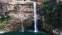 Keoti falls in Rewa City | |
 Rewa  Rewa | |
| Coordinates: 24.53°N 81.3°E | |
| Country | India |
| State | Madhya Pradesh |
| District | Rewa |
| Founded by | Vikramaditya Singh |
| Government | |
| • Type | Municipal Corporation |
| • Body | Rewa Municipal Corporation |
| Area | |
| • City | 69 km2 (27 sq mi) |
| • Metro | 146 km2 (56 sq mi) |
| Area rank | 22nd[2] |
| Elevation | 304 m (997 ft) |
| Population (2011) | |
| • City | 236,516 |
| • Rank | 5th[2] |
| • Density | 3,400/km2 (8,900/sq mi) |
| Languages | |
| • Official | Hindi |
| Time zone | UTC+5:30 (IST) |
| PIN | 486001 HPO 486002, 486003 |
| Telephone code | 07662 |
| ISO 3166 code | IN-MP |
| Vehicle registration | MP-17 |
| Website | www |
History
The district derives its name from the town of Rewa, the district headquarters, which is another name for the Narmada River. The territories now included in the district were held by the imperial Maurya dynasty, which ruled in the 3rd century BC. The area came under the Kalachuris from the 9th to the end of the 12th century. In the 13th century, Ulugh Khan, brother of Sultan Alauddin, drove the Baghela king east into the area, where he founded the Princely State of Rewa. This dynasty continued until the last successor, Martand Singh, abdicated and acceded rule to the Dominion of India in 1947. The present Rewa district came into existence in 1950 when the Provinces and States Order (transfer of enclaves) was put into effect. Prior to August 1947, the district, along with the Raghurajnagar tehsil of the former Rewa state, corresponded to that state's north Rewa district.[3]
Demographics
As of 2011, Rewa had a population of about 2,35,654 out of which 1,24,012 are males and 1,11,642 are females. Rewa has an average literacy rate of 86.31%, male literacy is 91.67%, and female literacy is 80.40%. In Rewa, 10.76% of the population is under 6 years old.
| Rewa City | Total | Male | Female |
| City Population | 235,654 | 124,012 | 111,642 |
| Literates | 181,504 | 101,092 | 80,412 |
| Children (0-6) | 25,356 | 13,731 | 11,625 |
| Average Literacy (%) | 86.31 % | 91.67 % | 80.40 % |
| Sex ratio | 900 (females per 1000 males) | ||
Hinduism is majority religion in Rewa city with 95.93% followers. Islam is second most popular religion in city of Rewa with approximately 3.61% following it. In Rewa city, Christianity is followed by 0.08%, Jainism by 0.03%, Sikhism by 0.04% and Buddhism by 0.04%. Around 0.01% stated 'Other Religion', approximately 0.26% stated 'No Particular Religion'.
| Description | Total | Percentage |
| Hindu | 2,268,838 | 95.93 % |
| Muslims | 85,414 | 3.61% |
| Christian | 1,964 | 0.08 % |
| Sikh | 832 | 0.04 % |
| Jain | 655 | 0.03 % |
| Not Stated | 6,185 | 0.26 % |
| Buddhist | 986 | 0.04 % |
| Others | 232 | 0.01 % |
Governance
Rewa district, itself Rewa Lok Sabha constituency is divided into following 8 Vidhan Sabha (Legislative assembly) Constituencies:
Climate
Rewa has a humid subtropical climate, with cold, misty winters, hot summer and a humid monsoon season. Summers start in late March and go on till mid-June, the average temperature being around 30 °C (86 °F), with the peak of summer in May, when the highs regularly exceed 45 °C (104 °F). The monsoon starts in late June and ends in late September. These months see about 40 inches (1025 mm) of precipitation. The average temperature is around 25 °C (77 °F) and the humidity is quite high. Temperatures rise again up to late October when winter starts, which lasts up to early March. Winters in Rewa are cold and misty with average temperatures around 15 °C (58 °F) and little rain. The winter peaks in January when temperatures may drop close to freezing on some nights. The total annual rainfall is about 1128 mm (44 inches).
| Climate data for Rewa, Madhya Pradesh (1981–2010, extremes 1965–2012) | |||||||||||||
|---|---|---|---|---|---|---|---|---|---|---|---|---|---|
| Month | Jan | Feb | Mar | Apr | May | Jun | Jul | Aug | Sep | Oct | Nov | Dec | Year |
| Record high °C (°F) | 31.4 (88.5) |
36.5 (97.7) |
40.7 (105.3) |
45.0 (113.0) |
46.8 (116.2) |
46.6 (115.9) |
43.2 (109.8) |
39.4 (102.9) |
37.6 (99.7) |
38.6 (101.5) |
36.2 (97.2) |
31.1 (88.0) |
46.8 (116.2) |
| Average high °C (°F) | 23.7 (74.7) |
27.0 (80.6) |
33.1 (91.6) |
38.6 (101.5) |
41.1 (106.0) |
38.8 (101.8) |
33.3 (91.9) |
31.8 (89.2) |
32.0 (89.6) |
32.2 (90.0) |
28.9 (84.0) |
25.3 (77.5) |
32.2 (90.0) |
| Average low °C (°F) | 8.1 (46.6) |
10.8 (51.4) |
15.6 (60.1) |
21.1 (70.0) |
25.6 (78.1) |
26.8 (80.2) |
25.0 (77.0) |
24.3 (75.7) |
23.4 (74.1) |
19.1 (66.4) |
13.1 (55.6) |
8.4 (47.1) |
18.4 (65.1) |
| Record low °C (°F) | 0.6 (33.1) |
1.6 (34.9) |
6.4 (43.5) |
11.6 (52.9) |
17.6 (63.7) |
20.1 (68.2) |
15.2 (59.4) |
20.3 (68.5) |
10.2 (50.4) |
9.0 (48.2) |
4.4 (39.9) |
1.9 (35.4) |
0.6 (33.1) |
| Average rainfall mm (inches) | 17.4 (0.69) |
21.8 (0.86) |
7.1 (0.28) |
5.7 (0.22) |
10.5 (0.41) |
114.6 (4.51) |
298.4 (11.75) |
296.4 (11.67) |
208.5 (8.21) |
44.7 (1.76) |
7.4 (0.29) |
7.3 (0.29) |
1,039.8 (40.94) |
| Average rainy days | 1.5 | 1.7 | 0.8 | 0.5 | 1.2 | 5.3 | 12.6 | 12.4 | 8.3 | 2.2 | 0.5 | 0.6 | 47.5 |
| Average relative humidity (%) (at 17:30 IST) | 58 | 51 | 36 | 28 | 31 | 49 | 72 | 77 | 73 | 60 | 60 | 61 | 54 |
| Source: India Meteorological Department[5][6] | |||||||||||||
Transportation
_Express_Route_map.jpg.webp)
Rail
Rewa railway station is connected to Satna through the 50 km Satna-Rewa branch line. Satna falls on the Howrah-Allahabad-Mumbai line.
Road & Air
The highways crosses through the city are NH 7, NH 27, and NH 75.
Closest major Airport to Rewa is in Prayagraj which is 130 kilometers (80.7 miles) away and has flights to major destinations such as Delhi, Bangaluru, Mumbai, Kolkata etc. Other airports are at Chorahta Airport Rewa, Khajuraho, Jabalpur and Varanasi.
Notable people
- Awadhesh Pratap Singh, Politician and Member of the Constituent Assembly
- Sriniwas Tiwari , former Speaker of Legislative assembly of Madhya Pradesh
- Avani Chaturvedi, India's first female fighter pilot
- Mohena Singh, Indian television actress
- Kumud Mishra, Indian actor
- Ram Vilas Vedanti, Indian Politician, former MP and Member of Shri Ram Janmabhumi Trust
- Govind Narayan Singh, former Chief Minister of Madhya Pradesh
- Rajendra Shukla, Politician and Member of the State Assembly
References
- "Rewa Info" (PDF).
- "Census of India 2011 - MADHYA PRADESH" (PDF). censusindia.gov.in. Retrieved 18 September 2020.
- New Delhi, Census of India (2011). "District census hand book, Rewa (village and town directory)" (PDF). p. xvii. Archived from the original (PDF) on 7 October 2016. Retrieved 7 October 2016.
- "DISTRICT PROFILE - REWA" (PDF). hindustanmerijaan.com. Retrieved 18 September 2020.
- "Station: Rewa Climatological Table 1981–2010" (PDF). Climatological Normals 1981–2010. India Meteorological Department. January 2015. pp. 667–668. Archived from the original (PDF) on 5 February 2020. Retrieved 28 December 2020.
- "Extremes of Temperature & Rainfall for Indian Stations (Up to 2012)" (PDF). India Meteorological Department. December 2016. p. M128. Archived from the original (PDF) on 5 February 2020. Retrieved 28 December 2020.
External links
| Authority control |
|---|