Ribeira do Rabil
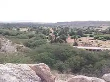
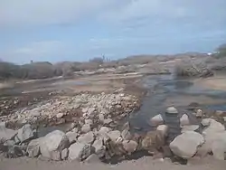
Ribeira do Rabil is a seasonal stream in the central and western part of the island of Boa Vista in Cape Verde. It is 27 km long, and its basin area is 199 km2 (77 sq mi).[1] Its source is in the southeastern part of the island, north of the island's highest point Monte Estância. It flows generally northwest, passes east of the town Rabil and flows into the Atlantic Ocean near the Aristides Pereira International Airport. The estuary, Lagoa do Rabil, is an important wetland area.[2]
Palm trees along Ribeira do Rabil
| Ribeira do Rabil | |
|---|---|
 | |
| Location | |
| Country | Cape Verde |
| Physical characteristics | |
| Source | |
| • location | Monte Estância, Boa Vista |
| Mouth | |
• location | Atlantic Ocean |
• coordinates | 16.0827°N 22.8469°W |
| Length | 27 km (17 mi) |
| Basin size | 199 km2 (77 sq mi) |
See also
- List of streams in Cape Verde
References
- Estatísticas do Ambiente - 2016, Instituto Nacional de Estatística, p. 22
- "Lagoa de Rabil". Ramsar Sites Information Service. Retrieved 3 August 2018.
The island of Boa Vista | ||
|---|---|---|
| Santa Isabel | 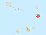 | |
| São João Baptista | ||
| Mountains | ||
| Islets | ||
| Beaches | ||
| Other geographical features | ||
| ||
This article is issued from Wikipedia. The text is licensed under Creative Commons - Attribution - Sharealike. Additional terms may apply for the media files.