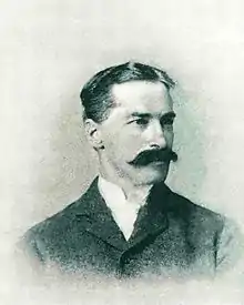
Richard Urquhart Goode
Richard Urquhart Goode (December 8, 1858 – June 9, 1903) was an American geographer. He was born in Bedford, Virginia. He attended the University of Virginia before joining the U.S. Army Corps of Engineers in 1877. In 1879, he became a topographer with the newly created United States Geological Survey where he worked until 1879. From 1882-1882, Goode was attached to the Northern Transcontinental Railroad Survey as an engineer and topographer. In 1884 he rejoined the USGS. In 1888, while on a leave of absence from the USGS, Goode served as an engineer and astronomer for the Panama Canal Company. In 1889, he rejoined the Survey as a geographer and was placed in charge of surveys of the Pacific Coast states - California, Oregon, and Washington. He served in that role until his death.[1]
Richard Urquhart Goode | |
|---|---|
 A photograph of Goode taken shortly before his death | |
| Born | December 8, 1858 |
| Died | June 9, 1903 (aged 44) Rockville, Maryland, U.S. |
| Nationality | American |
| Occupation | Geologist |
| Known for | Goode Mountain, United States Geological Survey |
Goode married Sophie J. Parks of Norfolk, Virginia in 1889. They had three children. He was a member of the Washington Academy of Sciences, the National Geographic Society, and the Cosmos Club. From 1901 to 1903, he was the chairman of the Committee on Technical Meetings at the National Geographic Society.[2]
Honors
- Mount Goode, a 10,610-ft summit located in the Chugach Mountains of Alaska was named for him in 1924.[3]
- Goode Mountain, the highest peak in North Cascades National Park and fourth highest in Chelan County, Washington is named after Mr. Goode[4]
- Mount Goode, a 13,085-ft summit on the crest of the Sierra Nevada in Kings Canyon National Park of California was officially adopted in 1926.[5]
Publications
- "The geography and geology of Alaska : a summary of existing knowledge" with Alfred Hulse Brooks and Cleveland Abbe. US Geological Survey Professional Paper No. 45, 1906.
- The Idaho-Montana Boundary Line National Geographic Magazine. January, 1900, Vol. 11, No. 1. pages 23–28.
- Results of primary triangulation and primary traverse, fiscal year 1901-2 US Geological Survey Bulletin No. 201, 1902
- Results of spirit-leveling, fiscal year 1900-1901 US Geological Survey Bulletin No. 185, 1901
- Survey of the boundary line between Idaho and Montana, from the international boundary to the crest of the Bitterroot Mountains US Geological Survey Bulletin No. 170, 1900
- Magnetic declination (1899)
- West Virginia Geological and Economic Survey: Reports (1899)
References
- "Richard Goode's Funeral.: Service This Morning at St. Margaret's Episcopal Church". Washington Post (p. 7). June 11, 1903.
- "Richard Urquhard Goode". National Geographic Magazine. 14 (November 1903): 424–425. January 1, 1903.
- "Mount Goode". Geographic Names Information System. United States Geological Survey. Retrieved 2020-02-29.
- "Goode Mountain". Peakware.com. Archived from the original on 2016-03-04.
- Sixth Report of the United States Geographic Board, 1890 to 1932, US Government Printing Office. 1932. page 329.
External links
- Works by or about Richard Urquhart Goode at Internet Archive
- Works by Richard Urquhart Goode at LibriVox (public domain audiobooks)
