Richland Township, Greene County, Indiana
Richland Township is one of fifteen townships in Greene County, Indiana, USA. As of the 2010 census, its population was 5,019.[1]
| Historical population | |||
|---|---|---|---|
| Census | Pop. | %± | |
| 2000 | 5,008 | — | |
| 2010 | 5,019 | 0.2% | |
| Source: US Census Bureau | |||
Richland Township | |
|---|---|
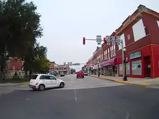 Downtown Bloomfield, in Richland Township | |
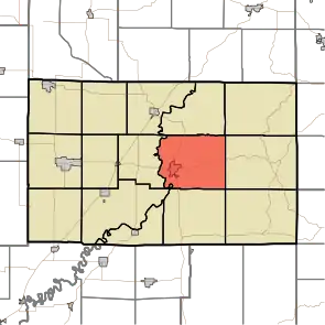 Location in Greene County | |
| Coordinates: 39°02′05″N 86°54′01″W | |
| Country | United States |
| State | Indiana |
| County | Greene |
| Government | |
| • Type | Indiana township |
| Area | |
| • Total | 43.16 sq mi (111.8 km2) |
| • Land | 42.79 sq mi (110.8 km2) |
| • Water | 0.37 sq mi (1.0 km2) 0.86% |
| Elevation | 499 ft (152 m) |
| Population (2010) | |
| • Total | 5,019 |
| • Density | 117.3/sq mi (45.3/km2) |
| GNIS feature ID | 0453794 |
Geography
According to the 2010 census, the township has a total area of 43.16 square miles (111.8 km2), of which 42.79 square miles (110.8 km2) (or 99.14%) is land and 0.37 square miles (0.96 km2) (or 0.86%) is water.[1] The streams of Beech Creek, Letsinger Branch, Miller Branch, Ore Branch, Plummer Creek, Ritter Branch, Skinner Branch, Stalcup Branch and Wildcat Branch run through this township. It is bounded by Township Road 400 to the north, and the west fork of the White River to the west.
Cities and towns
- Bloomfield (the county seat)
Unincorporated towns
(This list is based on USGS data and may include former settlements.)
Adjacent townships
- Highland Township (north)
- Beech Creek Township (northeast)
- Center Township (east)
- Jackson Township (southeast)
- Taylor Township (south)
- Washington Township (southwest)
- Fairplay Township (west)
- Jefferson Township (northwest)
Cemeteries
The township contains four cemeteries: Flater, Mount Zion, Union Bethel, and Van Slyke.
References
- "Population, Housing Units, Area, and Density: 2010 - County -- County Subdivision and Place -- 2010 Census Summary File 1". United States Census. Archived from the original on 2020-02-10. Retrieved 2013-05-10.
External links
- Indiana Township Association
- United Township Association of Indiana
- Bloomfield Volunteer Fire Department
- Richland Township Volunteer Fire Department
Municipalities and communities of Greene County, Indiana, United States | ||
|---|---|---|
| Cities | Map of Indiana highlighting Greene County | |
| Towns | ||
| Townships | ||
| CDPs | ||
| Other unincorporated communities |
| |
| Footnotes | ‡This populated place also has portions in an adjacent county or counties | |
| ||