Richtersveld Local Municipality
Richtersveld is an administrative area in the Namakwa District of Northern Cape in South Africa.
Richtersveld | |
|---|---|
 Seal | |
.svg.png.webp) Location in the Northern Cape | |
| Coordinates: 28°45′S 17°00′E | |
| Country | South Africa |
| Province | Northern Cape |
| District | Namakwa |
| Seat | Port Nolloth |
| Wards | 4 |
| Government | |
| • Type | Municipal council |
| • Mayor | Richard Leon Ambrosini |
| Area | |
| • Total | 9,608 km2 (3,710 sq mi) |
| Population (2011)[2] | |
| • Total | 11,982 |
| • Density | 1.2/km2 (3.2/sq mi) |
| Racial makeup (2011) | |
| • Black African | 13.1% |
| • Coloured | 76.6% |
| • Indian/Asian | 0.5% |
| • White | 8.5% |
| First languages (2011) | |
| • Afrikaans | 87.0% |
| • Xhosa | 6.1% |
| • English | 2.6% |
| • Other | 4.3% |
| Time zone | UTC+2 (SAST) |
| Municipal code | NC061 |
The municipality is named after Reverend W Richter, a Dutch missionary of the 20th century who opened a mission station in Koeboes.[4]
History
Richtersveld is part of Little Namaqualand, the part of Namaqualand south of the Orange River. The original inhabitants of Namaqualand were overwhelmingly Khoi Khoi, but also included some San people.[5]
During the 19th century, other people started settling in Little Namaqualand. These included some white Trekboere, and also a number of so-called basters. Missionaries too started showing an interest in Little Namaqualand. The Rhenish Missionary Society established a mission station under the charge of Reverend Hein at Kuboes during the mid 19th century.[5]
On 23 December 1847 the British Crown, through annexation, extended the northern boundary of the then Cape Province from the Buffels River up to the Orange River. From that date the whole of Little Namaqualand (including the Richtersveld) became subject to British rule.[5]
In 1925 diamonds were discovered near Port Nolloth. In 1927 a particularly rich deposit was found at the mouth of the Orange River at Alexander Bay. Many people moved into the area. Throughout the 1960s through 1998, a Light Infantry Regiment of the SADF was garrisoned here along with 2 batteries of Self-Propelled Artillery[5]
Geography
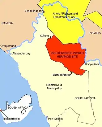
The municipality covers an area of 9,608 square kilometres (3,710 sq mi) in the north-western corner of South Africa where the Atlantic coast meets the Orange River border with Namibia. It borders on the Nama Khoi Local Municipality to the south and east, Namibia's ǁKaras Region to the north, and the Atlantic Ocean to the west.
At the time of the 2011 census the municipality had a population of 11,982 in 3,543. The principal language was Afrikaans which is spoken by 87.0% of the population, followed by isiXhosa (spoken by 6.1%) and English (spoken by 2.6%). 76.6% of the population identified themselves as "Coloured", 13.1% as "Black African", and 8.5% as "White".
The principal town of the municipality is Port Nolloth (population 6,092 in 2011) which lies on the Atlantic coast in the southern part of the municipality. Other towns are Alexander Bay (pop. 1,736) at the mouth of the Orange River, and Sanddrif (pop. 1,854) which is adjacent to the Baken diamond mine. Other smaller settlements in the municipality include Sendelingsdrif (pop. 192) and Grootderm (pop. 80) along the Orange River, and Kuboes (pop. 948), Eksteenfontein (pop. 531) and Lekkersing (pop. 363) in the interior.
The northernmost part of the municipal area is part of the ǀAi-ǀAis/Richtersveld Transfrontier Park, while immediately to the south of the park is the Richtersveld Cultural and Botanical Landscape World Heritage Site.
The main transport route in the municipality is the R382 road which runs from Steinkopf (where it connects to the N7 highway) west to Port Nolloth, and then north along the coast to Alexander Bay.
Politics
The municipal council consists of seven members elected by mixed-member proportional representation. Four councillors are elected by first-past-the-post voting in four wards, while the remaining three are chosen from party lists so that the total number of party representatives is proportional to the number of votes received. In the election of 3 August 2016 the African National Congress (ANC) won a majority of four seats on the council. The following table shows the results of the election.[6][7]
| Party | Votes | Seats | ||||||
|---|---|---|---|---|---|---|---|---|
| Ward | List | Total | % | Ward | List | Total | ||
| ANC | 2,297 | 2,317 | 4,614 | 52.7 | 2 | 2 | 4 | |
| Democratic Alliance | 2,030 | 2,021 | 4,051 | 46.3 | 2 | 1 | 3 | |
| Economic Freedom Fighters | 47 | 42 | 89 | 1.0 | 0 | 0 | 0 | |
| Total | 4,374 | 4,380 | 8,754 | 100.0 | 4 | 3 | 7 | |
| Spoilt votes | 51 | 47 | 98 | |||||
References
- "Contact list: Executive Mayors". Government Communication & Information System. Archived from the original on 14 July 2010. Retrieved 22 February 2012.
- "Statistics by place". Statistics South Africa. Retrieved 27 September 2015.
- "Statistics by place". Statistics South Africa. Retrieved 27 September 2015.
- South African Languages - Place names
- Richtersveld Decision, 22 March 2001, pp. 15-20
- "Results Summary – All Ballots: Richtersveld" (PDF). Independent Electoral Commission. Retrieved 11 May 2017.
- "Seat Calculation Detail: Richtersveld" (PDF). Independent Electoral Commission. Retrieved 11 May 2017.
External links
Municipalities and communities of Namakwa District Municipality, Northern Cape | ||
|---|---|---|
District seat: Springbok | ||
| Hantam | .svg.png.webp) Namakwa District within South Africa | |
| Kamiesberg | ||
| Karoo Hoogland | ||
| Khâi-Ma | ||
| Nama Khoi | ||
| Richtersveld | ||
.svg.png.webp)