Rio Grande, Ohio
Rio Grande (/ˈraɪoʊ ˈɡrænd/ RY-oh GRAND) is a village in Gallia County, Ohio, United States. The population was 830 at the 2010 census. It is part of the Point Pleasant, WV–OH Micropolitan Statistical Area.
Rio Grande, Ohio | |
|---|---|
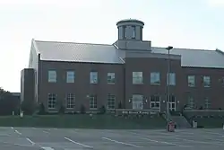 Bob Evans Farm Hall on the university campus | |
 Flag | |
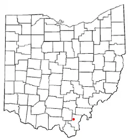 Location of Rio Grande, Ohio | |
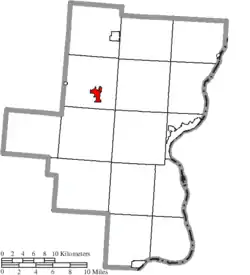 Location of Rio Grande in Gallia County | |
| Coordinates: 38°53′1″N 82°22′48″W | |
| Country | United States |
| State | Ohio |
| County | Gallia |
| Township | Raccoon |
| Area | |
| • Total | 1.38 sq mi (3.58 km2) |
| • Land | 1.37 sq mi (3.55 km2) |
| • Water | 0.01 sq mi (0.03 km2) |
| Elevation | 650 ft (198 m) |
| Population | |
| • Total | 830 |
| • Estimate (2019)[4] | 781 |
| • Density | 570.07/sq mi (220.16/km2) |
| Time zone | UTC-5 (Eastern (EST)) |
| • Summer (DST) | UTC-4 (EDT) |
| ZIP code | 45674 |
| Area code(s) | 740 |
| FIPS code | 39-67258[5] |
| GNIS feature ID | 1076745[2] |
Although the town is named after the river in the southern United States, its name is pronounced "Rye-O Grand" rather than the traditional Spanish pronunciation so that it rhymes with "Ohio."
Rio Grande is home to the University of Rio Grande/Rio Grande Community College, the alma mater of Bevo Francis, who set and until recently still held the NCAA basketball single-game scoring record.[6] It is also the original location of Bob Evans Restaurants. The restaurant chain began as a single truck stop diner in Rio Grande.
History
The name of Rio Grande was chosen to commemorate the Mexican–American War.[7]
Geography
Rio Grande is located at 38°53′1″N 82°22′48″W (38.883731, -82.379968).[8]
According to the United States Census Bureau, the village has a total area of 1.37 square miles (3.55 km2), of which 1.36 square miles (3.52 km2) is land and 0.01 square miles (0.03 km2) is water.[9]
Rio Grande is located very close to Raccoon Creek, a tributary of the Ohio River.[10]
Demographics
| Historical population | |||
|---|---|---|---|
| Census | Pop. | %± | |
| 1940 | 204 | — | |
| 1950 | 388 | 90.2% | |
| 1960 | 333 | −14.2% | |
| 1970 | 814 | 144.4% | |
| 1980 | 864 | 6.1% | |
| 1990 | 995 | 15.2% | |
| 2000 | 915 | −8.0% | |
| 2010 | 830 | −9.3% | |
| 2019 (est.) | 781 | [4] | −5.9% |
| U.S. Decennial Census[11] | |||
2010 census
As of the census[3] of 2010, there were 830 people, 223 households, and 142 families residing in the village. The population density was 610.3 inhabitants per square mile (235.6/km2). There were 292 housing units at an average density of 214.7 per square mile (82.9/km2). The racial makeup of the village was 87.2% White, 8.8% African American, 0.2% Native American, 0.6% Asian, 0.7% from other races, and 2.4% from two or more races. Hispanic or Latino of any race were 1.3% of the population.
There were 223 households, of which 38.1% had children under the age of 18 living with them, 39.0% were married couples living together, 18.4% had a female householder with no husband present, 6.3% had a male householder with no wife present, and 36.3% were non-families. 27.8% of all households were made up of individuals, and 9.4% had someone living alone who was 65 years of age or older. The average household size was 2.35 and the average family size was 2.80.
The median age in the village was 21.9 years. 16% of residents were under the age of 18; 47% were between the ages of 18 and 24; 17% were from 25 to 44; 12.6% were from 45 to 64; and 7.3% were 65 years of age or older. The gender makeup of the village was 50.4% male and 49.6% female.
2000 census
As of the census[5] of 2000, there were 915 people, 232 households, and 145 families residing in the village. The population density was 764.1 people per square mile (294.4/km2). There were 277 housing units at an average density of 231.3 per square mile (89.1/km2). The racial makeup of the village was 90.82% White, 4.04% African American, 1.09% Native American, 2.08% Asian, 0.22% from other races, and 1.75% from two or more races. Hispanic or Latino of any race were 0.87% of the population.
There were 232 households, out of which 35.8% had children under the age of 18 living with them, 35.8% were married couples living together, 22.0% had a female householder with no husband present, and 37.5% were non-families. 26.7% of all households were made up of individuals, and 6.0% had someone living alone who was 65 years of age or older. The average household size was 2.31 and the average family size was 2.82.
In the village, the population was spread out, with 15.8% under the age of 18, 53.3% from 18 to 24, 15.6% from 25 to 44, 10.8% from 45 to 64, and 4.4% who were 65 years of age or older. The median age was 21 years. For every 100 females there were 97.6 males. For every 100 females age 18 and over, there were 97.4 males.
The median income for a household in the village was $16,932, and the median income for a family was $29,167. Males had a median income of $25,139 versus $24,583 for females. The per capita income for the village was $10,822. About 32.6% of families and 35.9% of the population were below the poverty line, including 40.9% of those under age 18 and none of those age 65 or over.
Education
Public education in the village of Rio Grande is provided by the Gallipolis City School District. Campuses serving the village include Rio Grande Elementary School, Gallia Academy Middle School, and Gallia Academy High School.
References
- "2019 U.S. Gazetteer Files". United States Census Bureau. Retrieved July 28, 2020.
- "US Board on Geographic Names". United States Geological Survey. 2007-10-25. Retrieved 2008-01-31.
- "U.S. Census website". United States Census Bureau. Retrieved 2013-01-06.
- "Population and Housing Unit Estimates". United States Census Bureau. May 24, 2020. Retrieved May 27, 2020.
- "U.S. Census website". United States Census Bureau. Retrieved 2008-01-31.
- Mike Puma. "At one time, everyone knew Bevo".
In the early 1950s, Francis became a national sensation playing for tiny Rio (pronounced RYE-oh) Grande College in southeastern Ohio. Almost a half-century later, many of his scoring records still stand. The 6-foot-9, sweet-shooting Francis still holds the college record for most points scored in a game (113) and his 46.5 average in the 1953-54 season remains the NCAA Division II mark.
- Peacefull, Leonard (1996). A Geography of Ohio. Kent State University Press. p. 219. ISBN 9780873385251. Retrieved 8 December 2013.
- "US Gazetteer files: 2010, 2000, and 1990". United States Census Bureau. 2011-02-12. Retrieved 2011-04-23.
- "US Gazetteer files 2010". United States Census Bureau. Archived from the original on 2012-01-24. Retrieved 2013-01-06.
- "State of Ohio GIS Databases". Archived from the original on 2011-08-21. Retrieved 2011-03-06.
- "Census of Population and Housing". Census.gov. Retrieved June 4, 2015.
Municipalities and communities of Gallia County, Ohio, United States | ||
|---|---|---|
| Villages | 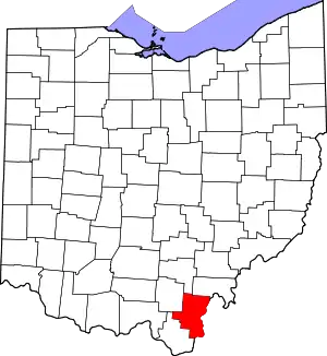 Map of Ohio highlighting Gallia County | |
| Townships | ||
| CDP | ||
| Unincorporated communities | ||
| ||