River Blyth, Northumberland
The River Blyth flows eastwards through southern Northumberland into the North Sea at the town of Blyth. It flows through Plessey Woods Country Park.[2] The River Pont is a tributary. The Blyth is 27 miles (44 km) long and the Pont is 17 miles (28 km).[3]
| River Blyth | |
|---|---|
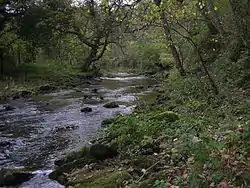 River Blyth near Bedlington | |
 Location within Northumberland | |
| Location | |
| Country | United Kingdom |
| County | Northumberland |
| Physical characteristics | |
| Source | |
| • location | Kirkheaton,[1] Northumberland, England |
| • elevation | 215 m (705 ft) |
| Mouth | |
• location | Blyth |
• coordinates | 55.1165°N 1.4891°W |
| Length | 44 km (27 mi) |
| Discharge | |
| • location | Hartford Bridge, Northumberland |
| • average | 2.14 m3/s (76 cu ft/s) |
The tidal limit of the river is at Bebside. The estuary widens from this point eastwards and with the addition of a beck that enters on the northern side (Sleek Burn), it covers an area of 415 acres (168 hectares).[4]
Ecologists have suggested that a dam on the river at Humford Country Park in Bedlington could be removed to allow for fish migration. The local community have expressed a desire to keep the dam as it is a local beauty spot; they have suggested that a fish passage be built alongside instead.[5]
References
- "Blyth from Source to How Burn". environment.data.gov.uk. Retrieved 19 February 2018.
- Aldred, Jessica (24 July 2008). "Otter spotting in Northumberland". The Guardian. Retrieved 19 February 2018.
- "The Northumberland Catchment" (PDF). environmentdata.org. Environment Agency. p. 3. Retrieved 19 February 2018.
- "Blyth (N)". environment.data.gov.uk. Retrieved 19 February 2018.
- "Dam in park 'must not be removed'". News Post Leader. 4 August 2017. Retrieved 19 February 2018.
External links
 Media related to River Blyth, Northumberland at Wikimedia Commons
- Bridges On the Blyth