River Forth
The River Forth is a major river, 47 km (29 mi) long, whose drainage basin covers much of Stirlingshire in Scotland's Central Belt.[1] The Gaelic name is Abhainn Dubh, meaning "black river", in the upper reach above Stirling. Below the tidal reach,[2] (just after being crossed by the M9 motorway) its name is Uisge For.
| Forth | |
|---|---|
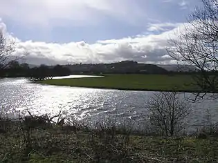 The River Forth meanders over fertile farmlands near Stirling | |
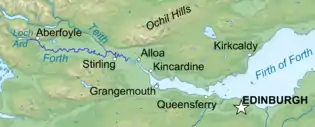 Course of River Forth | |
| Location | |
| Country | Scotland |
| Councils | Stirling |
| City | Stirling |
| Physical characteristics | |
| Source | Confluence of Duchray Water and the Avondhu River below Loch Ard |
| • coordinates | 56°10′52″N 4°24′30″W |
| • elevation | 33 m (108 ft) |
| Mouth | Firth of Forth, North Sea |
• location | UK |
• coordinates | 56°03′52″N 3°43′37″W |
• elevation | 0 m (0 ft) |
| Length | 47 km (29 mi) |
Name
Forth derives from Proto-Celtic *Vo-rit-ia (slow running), yielding Foirthe in Old Gaelic and Gweryd in Welsh.[3]
Course
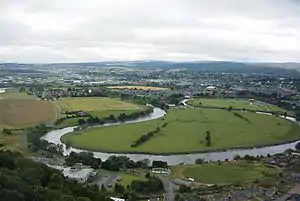
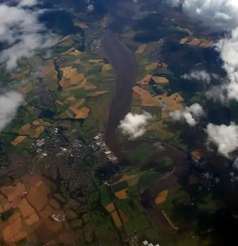
The Forth rises in the Trossachs, a mountainous area 30 km (19 mi) west of Stirling. Ben Lomond's eastern slopes drain into the Duchray Water which meets with Avondhu River coming from Loch Ard. The confluence of these two streams is the nominal start of the River Forth.[4] From there it flows roughly eastward, through Aberfoyle, joining with the Kelty Water, about 5 km further downstream. The flat expanse of the Carse of Stirling follows including Flanders Moss. It is joined by the River Teith (which itself drains Loch Venachar, Loch Lubnaig, Loch Achray, Loch Katrine, and Loch Voil) just west of the M9, the next tributary being the Allan Water just east of that motorway. From there it meanders into the ancient port of Stirling. At Stirling the river widens, becomes tidal,[5] and it is here that the last (seasonal) ford of the river exists. From Stirling, the Forth flows east accepting the Bannock Burn from the south before passing the town of Fallin. Two towns of Clackmannanshire are then passed: firstly Cambus (where it is joined by the river Devon), closely followed by Alloa. Upon reaching Airth on the south shore and Kincardine on the north, the river begins to widen and becomes the Firth of Forth.
Settlements on the river
The banks have many settlements including Aberfoyle, Gargunnock, Stirling, Fallin, Cambus, Throsk, Alloa, South Alloa, Dunmore, Airth, and Kincardine. Beyond this the brackish water is usually considered the Firth of Forth.
Navigation
In the sixteenth and seventeenth centuries Stirling harbour was a busy port, with goods coming into Scotland and being exported to Europe. Links with the Hansa towns were strong, and Stirling had a particularly close relationship with Bruges[6] in Belgium and Veere (known as Campvere)[7] in the Netherlands. After 1707 much of the trade shifted to the port of Glasgow, as trade with America became the new focus. During the First and Second World Wars, however, Stirling harbour thrived again as a gateway for supplies of tea to Scotland. Trade slowly returned after the wars but the few agricultural merchants based at Stirling found such shipping uncompetitive due to high shore dues levied by the harbour's owners. Today Stirling's harbour is not used but there are plans to redevelop it.
Bridges
Upstream of Stirling, the river is rather small and is crossed in numerous places (although prior to modern drainage works, the ground was often treacherously marshy near the riverbank). After its confluence with the Teith and Allan, the river is sufficiently wide that a significant bridge is required. A bridge has existed at Stirling since at least the 13th century, and until the opening of the road crossing at Kincardine in 1936, Stirling remained the easternmost road crossing. The Alloa Swing Bridge, a railway bridge between Alloa on the north shore and Throsk on the south opened in 1885 and was closed (and largely demolished) in 1970. Only the metal piers remain. The Clackmannanshire Bridge just upstream of the Kincardine Bridge opened on 19 November 2008. Much further downstream joining North Queensferry and South Queensferry is the famous Forth Bridge (a railway bridge) opened in 1890, and the Forth Road Bridge which opened in 1964. In 2011 construction began on the Queensferry Crossing, to the west of the Forth Road Bridge, which officially opened on 4 September 2017.[8]
Islands
Two islands known as inches form part of the meandering estuarine waters downstream from Stirling. Tullibody Inch near Cambus and Alloa Inch near Alloa are both fairly small and uninhabited.
On film and TV
- River Forth[9] (1956), a silent black and white short film (15 minutes) - includes scenes of animals being herded through the streets.
- Britain's Lost Routes with Griff Rhys Jones (2012) Episode 3 shows the difficulties cattle drovers might have encountered at Frew, and shows aerial shots and taking cows across the Auld Brig.[10]
- Sruth gu Sal - a look at the Forth river (2 Nov 2009) Episode 1 -25 mins[11]
See also
References
- "River Forth Catchment Profile" (PDF). SEPA. Retrieved 8 April 2017.
- "OS 25 inch, 1892-1905". National Library of Scotland - Map Images. Ordnance Survey. Retrieved 8 April 2017.
- Field, John:Place Names of Great Britain and Ireland, page 74. London, David & Charles, 1980
- "Interactive Map". RBMP. SEPA. Retrieved 8 April 2017.
- The new statistical account of Scotland. Edinburgh and London: W. Blackwood and Sons. 1845. p. 397. Retrieved 8 April 2017.
- "Scotland in Europe". BBC History. Retrieved 8 April 2017.
- Morris, David B. (1919). The Stirling merchant gild and life of John Cowane. Stirling: Morris, David B. pp. 195–210. Retrieved 8 April 2017.
- Johnson, Simon (4 September 2017). "Queen opens new Forth crossing 53 years to the day after she opened old road bridge". The Telegraph. ISSN 0307-1235. Retrieved 22 January 2018.
- "River Forth". Moving Image Archive. Templar Film Studios. Retrieved 4 April 2017.
- "Highland Cattle Drovers". BBC. Retrieved 10 April 2017.
- "Sruth gu Sal". BBC Alba. Retrieved 7 September 2017.
External links
| Wikimedia Commons has media related to River Forth. |
| Wikisource has the text of the 1911 Encyclopædia Britannica article Forth. |
- Scottish Parliament: Forth Crossing Bill Committee Report, March 2010
- River Forth Crossing: House of Commons debates 18 May 2009
- British Waterways: River Forth
- Gazetteer for Scotland: River Forth
- SCRAN image: Steam dredger, River forth, late 19th Century
- Stirling Council: River Forth
- Forth Ports PLC
- Scottish Environment Protection Agency (SEPA): River level data for River Forth
- Forth Estuary Forum, a Scottish Charity
- Forth District Salmon Fishery Board
- River Forth Fisheries Trust
- Forth Bridges Visitor Centre Trust
- FYCA Alloa Swing Bridge
- RIVER FORTH (1956) FORTH - POWERHOUSE FOR INDUSTRY (1968) (archive films about the River Forth from the National Library of Scotland: Scottish Screen Archive)