River aux Sables
The River aux Sables, also known as the Aux Sables River and the Rivière aux Sables, is a river in Algoma and Sudbury Districts, Ontario, Canada which flows from Lac aux Sables in Algoma District and empties into the Spanish River near the community of Massey.
| River aux Sables | |
|---|---|
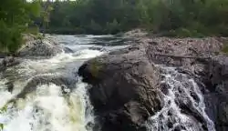 Rapids on the River aux Sables in Chutes Provincial Park | |
 Location of the mouth of the River aux Sables in Ontario | |
| Location | |
| Country | Canada |
| Province | Ontario |
| Districts | |
| Physical characteristics | |
| Source | Lac aux Sables |
| • location | Algoma, Unorganized, North Part, Algoma District |
| • coordinates | 46°50′19″N 82°21′42″W |
| • elevation | 451 m (1,480 ft) |
| Mouth | Spanish River |
• location | Sables-Spanish Rivers, Sudbury District |
• coordinates | 46°12′38″N 82°03′30″W |
• elevation | 178 m (584 ft) |
| Basin features | |
| Tributaries | |
| • right | West River aux Sables |
At one time, the river was used to transport logs to sawmills downstream. It flows through Chutes Provincial Park, which was named after chutes used to bypass rapids on this river. The river is now mainly used for recreational canoeing and kayaking.
Ontario Highway 810 follows the course of the river from Richie Falls in the north, south of Lac aux Sables, to Bull Lake in the south. Ontario Highway 553 continues south from there to Massey on Ontario Highway 17, first diverging from and then rejoining the river just north of Massey.
Tributaries
- West River aux Sables
See also
References
- "River aux Sables". Geographical Names Data Base. Natural Resources Canada. Retrieved 2010-06-24.
- "Toporama - Topographic Map Sheet 41J1, 41J8, 41J9, 41J16". Atlas of Canada. Natural Resources Canada. Archived from the original on 2010-02-10. Retrieved 2010-06-24.