Spanish River (Ontario)
The Spanish River is a river in Algoma District, Sudbury District and Greater Sudbury in Northwestern Ontario, Canada. It flows 338 kilometres (210 mi) in a southerly direction from its headwaters at Spanish Lake (west branch) and Duke Lake (east branch) to its mouth at the North Channel on Georgian Bay, Lake Huron just outside the community of Spanish.
| Spanish | |
|---|---|
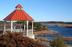 Mouth of the Spanish River at the Town of Spanish | |
 Location of the mouth of the Spanish River in Ontario | |
| Location | |
| Country | Canada |
| Province | Ontario |
| Physical characteristics | |
| Source | Biscotasi Lake |
| • location | Unorganized Sudbury, Sudbury District |
| • coordinates | 47°17′40″N 82°00′00″W |
| 2nd source | Alligator Lake |
| • location | Unorganized Sudbury, Sudbury District |
| • coordinates | 47°25′35″N 81°51′54″W |
| Source confluence | |
| • location | Unorganized Sudbury |
| • coordinates | 47°02′15″N 81°51′12″W |
| Mouth | North Channel (Lake Huron) |
• location | Spanish, Algoma District |
• coordinates | 46°11′04″N 82°18′41″W |
| Length | 338 km (210 mi) |
| Basin size | 14,000 km2 (5,400 sq mi) |
| Discharge | |
| • average | 150 m3/s (5,300 cu ft/s) |
The river is located almost entirely within the Sudbury District, except for brief passages into the city of Greater Sudbury near the communities of High Falls and Turbine and the river mouth in Algoma District.
Tributaries include Pogamasing Creek, Mogo Creek, Agnes River, the Aux Sables River, the Vermilion River and the Wakonassin River.
The river's name and the name of the nearby towns of Espanola and Spanish are said to be due to French explorers and Jesuit priests encountering Ojibwe peoples speaking Spanish in the area, apparently as a result of a Spanish woman having been taken captive during an expedition far to the south.
The Lower Spanish River Forest houses the world's oldest red pine and white pine forests, and much of that is under provincial protection in the form of provincial parks and reclamation acts.
History
This river has been used as a transportation corridor for thousands of years, initially by First Nations and later in the 19th century by fur traders. During the late 19th and mid 20th centuries, the river was used to transport timber from logging camps in the upper Sudbury District to Georgian Bay, where they were towed by tugs to sawmills on the Great Lakes. Until the mid-1960s, pulp wood, mainly jack pine, was driven down the river to the paper mill in Espanola. A diesel tug towed large rafts of logs the length of Agnew Lake to big Eddy dam where they were sluiced down a flume by crews with hand held pike poles. Secondary flumes took them past the High Falls and Nairn Falls power plants and on to Espanola. The sap and bark from the pulp logs was a major pollution source in the lower river.
In 1910, the river was the scene of a dramatic train derailment. It took place at the Canadian Pacific Railway bridge upstream from Espanola and downstream from the High Falls dam, about 5 miles (8.0 km) west of the town of Nairn.
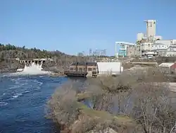
Today the river is mainly used for recreational canoeing and has been protected as a waterway provincial park. All park sites and portages are currently maintained by park staff. There are four hydroelectric dams on the river: one, known as Big Eddy, above High Falls forming Lake Agnew; High Falls dam about a kilometre below Big Eddy dam; Nairn Falls dam about 12 km below High Falls and the other at the Domtar mill in Espanola.
See also
Sources
- "Spanish River". Geographical Names Data Base. Natural Resources Canada. Retrieved March 6, 2011.
- "Spanish River". Atlas of Canada. Natural Resources Canada. February 4, 2010. Retrieved March 6, 2011. Shows the river course.
- "Facts about Canada – Rivers – Rivers Flowing into the Atlantic Ocean". Atlas of Canada. Natural Resources Canada. October 25, 2010. Retrieved March 6, 2011.
External links
| Wikimedia Commons has media related to Spanish River (Ontario). |
- The Spanish River, connected waterways
- Canoeing the Ancient Forest of the Spanish River
- Webshots, Great Pictures from Spanish River
- Pogamasing.com `How the Spanish River Got Its Name`
